Ḩajjah elevation
Ḩajjah, Yemen elevation is 1795 meters and Ḩajjah elevation in feet is 5889 ft above sea level [src 1]. Ḩajjah is a seat of a first-order administrative division (feature code) with elevation that is 483 meters (1585 ft) bigger than average city elevation in Yemen.
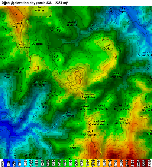
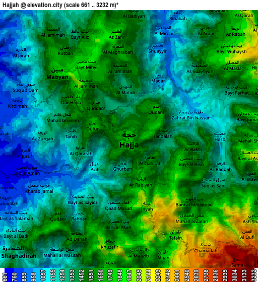
Below is the Elevation map of Ḩajjah, which displays elevation range with different colors. Scale of the first map is from 836 to 2351 m (2743 to 7713 ft) with average elevation of 1434.9 meters (=4708 ft) [note 1]
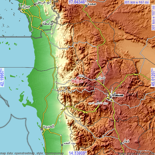
These maps also provides idea of topography and contour of this city, they are displayed at different zoom levels. More info about maps, scale and edge coordinates you can find below images.
| \ | Map #1 | Map #2 | Topo.Map |
| Scale [m] | 836..2351 m | 661..3232 m | × |
| Scale [ft] | 2743..7713 ft | 2169..10604 ft | × |
| Average | 1434.9 m = 4708 ft | 1464.3 m = 4804 ft | × |
| Width | 9.41 km = 5.8 mi | 18.82 km = 11.7 mi | 301 km = 187 mi |
| Height | 9.41 km = 5.8 mi | 18.82 km = 11.7 mi | 301.1 km = 187.1 mi |
| ↑Max Latitude | 15.736553° | 15.778846° | 17.04346° |
| Latitude at center | 15.69425° | 15.69425° | 15.69425° |
| ↓Min Latitude | 15.651939° | 15.609619° | 14.33605° |
| ← Min Longitude | 43.561875° | 43.517929° | 42.19957° |
| Longitude center | 43.60582° | 43.60582° | 43.60582° |
| →Max Longitude | 43.649765° | 43.693711° | 45.01207° |
Nearby cities:
Cities around Ḩajjah sort by population:
• Al Maḩwīt elevation 2124 m
25.8 km,  194°
194°
• Banī al ‘Awwām 1528 m
12.7 km, 188°
• Ar Rujum 1958 m
26.4 km,  173°
173°
• An Nāşirah 2327 m
23.4 km,  68°
68°
• Al Maghrabah 1252 m
21.4 km,  17°
17°
• Bayt ‘Adhāqah 2575 m
13.5 km,  130°
130°
• Waḑarah 1316 m
13.3 km,  277°
277°
• Kuḩlān ‘Affār 2368 m
12.9 km, 70°
• Ash Shaghādirah 1283 m
12.3 km,  227°
227°
• Banī an Nahārī 1703 m
8 km,  221°
221°
• Mabyan 1870 m
7.1 km,  312°
312°
• Sharas 1024 m
5.1 km, 66°
Multilingual:
 En español:
Ḩajjah elevación 1795 m.
 En France:
Ḩajjah élévation 1795 m.


Sources and notes:
- [note 1] Map square and city borders are not equal. Map elevation data is calculated only from area inside that square.
- [src 1] Elevation data from geonames database provided with same terms of usage.
- [src 2] The elevation map of Ḩajjah is generated using elevation data from NASA's 3 arcsec (90m) resolution SRTM data.
- [src 3] Base (background) map © OpenStreetMap contributors tiles are generated by Geofabrik and OpenTopoMap.
Copyright & License:
This Ḩajjah Elevation Map is licensed under CC BY-SA. You may reuse any part from this page, if you give a proper credit by linking to this URL:
 More info on terms of use page.