Bājil elevation
Bājil (Al Hudaydah), Yemen elevation is 191 meters and Bājil elevation in feet is 627 ft above sea level [src 1]. Bājil is a seat of a second-order administrative division (feature code) with elevation that is 1121 meters (3678 ft) smaller than average city elevation in Yemen.
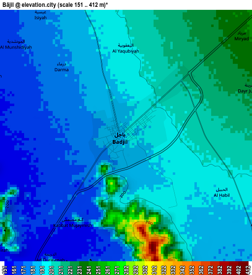
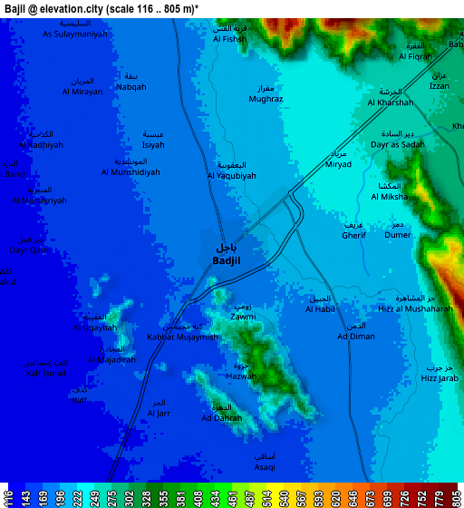
Below is the Elevation map of Bājil, which displays elevation range with different colors. Scale of the first map is from 151 to 412 m (495 to 1352 ft) with average elevation of 193.9 meters (=636 ft) [note 1]
These maps also provides idea of topography and contour of this city, they are displayed at different zoom levels. More info about maps, scale and edge coordinates you can find below images.
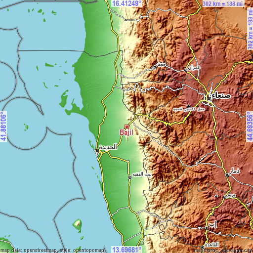
| \ | Map #1 | Map #2 | Topo.Map |
| Scale [m] | 151..412 m | 116..805 m | × |
| Scale [ft] | 495..1352 ft | 381..2641 ft | × |
| Average | 193.9 m = 636 ft | 203.3 m = 667 ft | × |
| Width | 9.44 km = 5.9 mi | 18.87 km = 11.7 mi | 302 km = 187.7 mi |
| Height | 9.44 km = 5.9 mi | 18.87 km = 11.7 mi | 302 km = 187.7 mi |
| ↑Max Latitude | 15.101412° | 15.143835° | 16.41249° |
| Latitude at center | 15.05898° | 15.05898° | 15.05898° |
| ↓Min Latitude | 15.01654° | 14.974091° | 13.69681° |
| ← Min Longitude | 43.243365° | 43.199419° | 41.88106° |
| Longitude center | 43.28731° | 43.28731° | 43.28731° |
| →Max Longitude | 43.331255° | 43.375201° | 44.69356° |
Nearby cities:
Cities around Bājil sort by population:
• Al Manşūrīyah elevation 122 m
41.5 km,  178°
178°
• Banī Ḩujjāj 745 m
39.9 km,  4°
4°
• Aş Şafaqayn 2157 m
38.4 km,  21°
21°
• Matwaḩ 2152 m
38.1 km,  88°
88°
• Markaz Bilād aţ Ţa‘ām 1689 m
36.7 km,  133°
133°
• As Sukhnah 247 m
33.5 km,  151°
151°
• Dhahi 78 m
29.1 km,  306°
306°
• Al Marāwi‘ah 77 m
29.1 km,  209°
209°
• ‘Ubāl 494 m
28.7 km,  105°
105°
• Al Khamīs 493 m
27.8 km,  59°
59°
• Al Mighlāf 132 m
27.5 km,  337°
337°
• Riqāb 1949 m
27.1 km,  135°
135°
Multilingual:
 En español:
Bājil elevación 191 m.
 En France:
Bājil élévation 191 m.


Sources and notes:
- [note 1] Map square and city borders are not equal. Map elevation data is calculated only from area inside that square.
- [src 1] Elevation data from geonames database provided with same terms of usage.
- [src 2] The elevation map of Bājil is generated using elevation data from NASA's 3 arcsec (90m) resolution SRTM data.
- [src 3] Base (background) map © OpenStreetMap contributors tiles are generated by Geofabrik and OpenTopoMap.
Copyright & License:
This Bājil Elevation Map is licensed under CC BY-SA. You may reuse any part from this page, if you give a proper credit by linking to this URL:
 More info on terms of use page.