Móng Cái elevation
Móng Cái (Quảng Ninh), Vietnam elevation is 9 meters and Móng Cái elevation in feet is 30 ft above sea level [src 1]. Móng Cái is a seat of a second-order administrative division (feature code) with elevation that is 119 meters (390 ft) smaller than average city elevation in Vietnam.
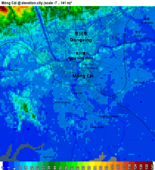
Below is the Elevation map of Móng Cái, which displays elevation range with different colors. Scale of the first map is from -7 to 141 m (-23 to 463 ft) with average elevation of 9.7 meters (=32 ft) [note 1]
These maps also provides idea of topography and contour of this city, they are displayed at different zoom levels. More info about maps, scale and edge coordinates you can find below images.
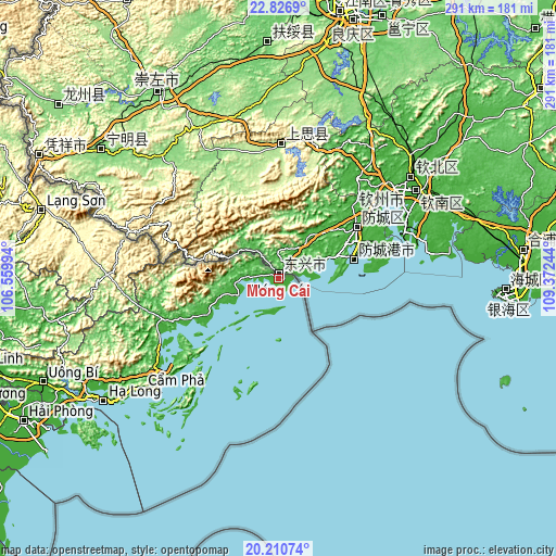
| \ | Map #1 | Map #2 | Topo.Map |
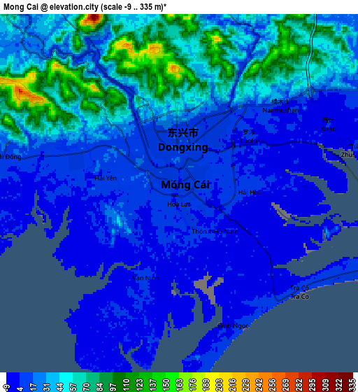
| Scale [m] | -7..141 m | -9..335 m | × |
| Scale [ft] | -23..463 ft | -30..1099 ft | × |
| Average | 9.7 m = 32 ft | 30.7 m = 101 ft | × |
| Width | 9.09 km = 5.6 mi | 18.18 km = 11.3 mi | 290.9 km = 180.8 mi |
| Height | 9.09 km = 5.6 mi | 18.18 km = 11.3 mi | 290.9 km = 180.8 mi |
| ↑Max Latitude | 21.565585° | 21.606448° | 22.8269° |
| Latitude at center | 21.52471° | 21.52471° | 21.52471° |
| ↓Min Latitude | 21.483824° | 21.442926° | 20.21074° |
| ← Min Longitude | 107.922245° | 107.878299° | 106.55994° |
| Longitude center | 107.96619° | 107.96619° | 107.96619° |
| →Max Longitude | 108.010135° | 108.054081° | 109.37244° |
Nearby cities:
Cities around Móng Cái sort by population:
• Hạ Long elevation 8 m
112.4 km,  235°
235°
• Cẩm Phả Mines 209 m
89.2 km,  230°
230°
• Lạng Sơn 265 m
129.7 km,  286°
286°
• Cát Bà 24 m
130.1 km, 227°
• Thị Trấn Cao Lộc 280 m
129.5 km, 287°
• An Châu 56 m
117.5 km,  259°
259°
• Trới 10 m
115 km, 241°
• Lộc Bình 279 m
110.9 km,  283°
283°
• Cẩm Phả 20 m
91.8 km, 231°
• Đình Lập 189 m
89.8 km,  271°
271°
• Cô Tô 9 m
64.8 km,  198°
198°
• Quảng Hà 10 m
23.3 km,  249°
249°
Multilingual:
 En español:
Móng Cái elevación 9 m.
 En France:
Móng Cái élévation 9 m.


Sources and notes:
- [note 1] Map square and city borders are not equal. Map elevation data is calculated only from area inside that square.
- [src 1] Elevation data from geonames database provided with same terms of usage.
- [src 2] The elevation map of Móng Cái is generated using elevation data from NASA's 3 arcsec (90m) resolution SRTM data.
- [src 3] Base (background) map © OpenStreetMap contributors tiles are generated by Geofabrik and OpenTopoMap.
Copyright & License:
This Móng Cái Elevation Map is licensed under CC BY-SA. You may reuse any part from this page, if you give a proper credit by linking to this URL:
 More info on terms of use page.