Cẩm Phả Mines elevation
Cẩm Phả Mines (Quảng Ninh), Vietnam elevation is 209 meters and Cẩm Phả Mines elevation in feet is 686 ft above sea level [src 1]. Cẩm Phả Mines is a populated place (feature code) with elevation that is 81 meters (266 ft) bigger than average city elevation in Vietnam.
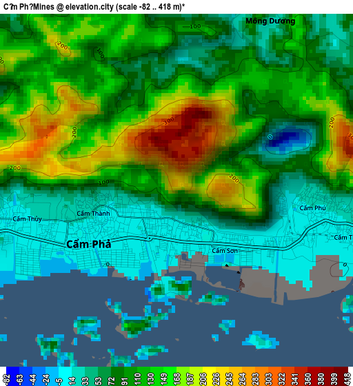
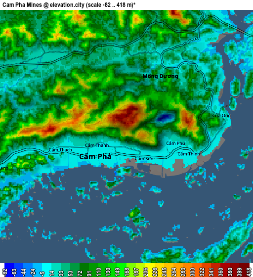
Below is the Elevation map of Cẩm Phả Mines, which displays elevation range with different colors. Scale of the first map is from -82 to 418 m (-269 to 1371 ft) with average elevation of 103.6 meters (=340 ft) [note 1]
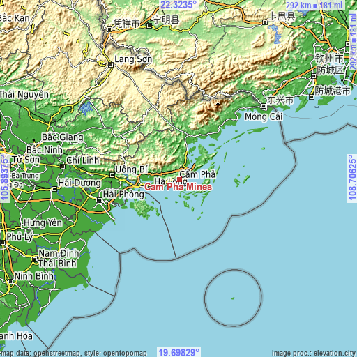
These maps also provides idea of topography and contour of this city, they are displayed at different zoom levels. More info about maps, scale and edge coordinates you can find below images.
| \ | Map #1 | Map #2 | Topo.Map |
| Scale [m] | -82..418 m | -82..418 m | × |
| Scale [ft] | -269..1371 ft | -269..1371 ft | × |
| Average | 103.6 m = 340 ft | 77 m = 253 ft | × |
| Width | 9.12 km = 5.7 mi | 18.24 km = 11.3 mi | 291.9 km = 181.4 mi |
| Height | 9.12 km = 5.7 mi | 18.24 km = 11.3 mi | 291.9 km = 181.4 mi |
| ↑Max Latitude | 21.057686° | 21.098691° | 22.3235° |
| Latitude at center | 21.01667° | 21.01667° | 21.01667° |
| ↓Min Latitude | 20.975642° | 20.934604° | 19.69829° |
| ← Min Longitude | 107.256055° | 107.212109° | 105.89375° |
| Longitude center | 107.3° | 107.3° | 107.3° |
| →Max Longitude | 107.343945° | 107.387891° | 108.70625° |
Nearby cities:
Cities around Cẩm Phả Mines sort by population:
• Haiphong elevation 12 m
66.2 km,  255°
255°
• Hạ Long 8 m
24.7 km,  252°
252°
• Thành Phố Uông Bí 11 m
55 km,  272°
272°
• Cát Bà 24 m
41.4 km,  219°
219°
• Quảng Hà 10 m
67.5 km,  44°
44°
• Núi Đèo 6 m
65.9 km, 260°
• Đình Lập 189 m
62.5 km,  340°
340°
• An Châu 56 m
58.6 km,  307°
307°
• Quảng Yên 9 m
52.3 km, 260°
• Cô Tô 9 m
48.6 km,  95°
95°
• Trới 10 m
32.1 km, 272°
• Cẩm Phả 20 m
2.9 km, 255°
Multilingual:
 En español:
Cẩm Phả Mines elevación 209 m.
 En France:
Cẩm Phả Mines élévation 209 m.
 Auf Deutsch:
Cẩm Phả Mines höhe über dem Meeresspiegel ist 209 m.

Sources and notes:
- [note 1] Map square and city borders are not equal. Map elevation data is calculated only from area inside that square.
- [src 1] Elevation data from geonames database provided with same terms of usage.
- [src 2] The elevation map of Cẩm Phả Mines is generated using elevation data from NASA's 3 arcsec (90m) resolution SRTM data.
- [src 3] Base (background) map © OpenStreetMap contributors tiles are generated by Geofabrik and OpenTopoMap.
Copyright & License:
This Cẩm Phả Mines Elevation Map is licensed under CC BY-SA. You may reuse any part from this page, if you give a proper credit by linking to this URL:
 More info on terms of use page.