An Châu elevation
An Châu (Bắc Giang), Vietnam elevation is 56 meters and An Châu elevation in feet is 184 ft above sea level [src 1]. An Châu is a seat of a second-order administrative division (feature code) with elevation that is 72 meters (236 ft) smaller than average city elevation in Vietnam.
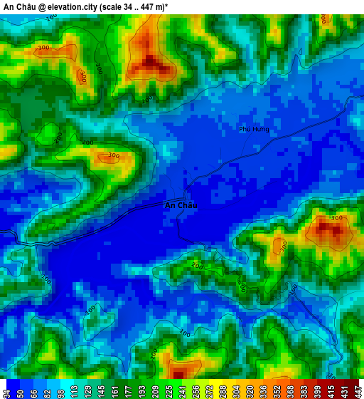
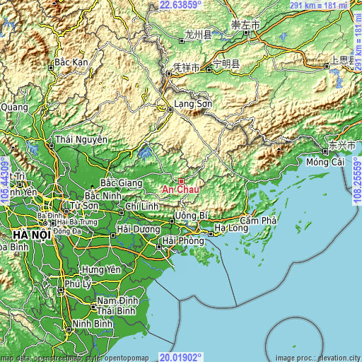
Below is the Elevation map of An Châu, which displays elevation range with different colors. Scale of the first map is from 34 to 447 m (112 to 1467 ft) with average elevation of 134.7 meters (=442 ft) [note 1]
These maps also provides idea of topography and contour of this city, they are displayed at different zoom levels. More info about maps, scale and edge coordinates you can find below images.
| \ | Map #1 | Topo.Map |
| Scale [m] | 34..447 m | × |
| Scale [ft] | 112..1467 ft | × |
| Average | 134.7 m = 442 ft | × |
| Width | 9.1 km = 5.7 mi | 291.3 km = 181 mi |
| Height | 9.1 km = 5.7 mi | 291.3 km = 181 mi |
| ↑Max Latitude | 21.375578° | 22.63859° |
| Latitude at center | 21.33465° | 21.33465° |
| ↓Min Latitude | 21.29371° | 20.01902° |
| ← Min Longitude | 106.805395° | 105.44309° |
| Longitude center | 106.84934° | 106.84934° |
| →Max Longitude | 106.893285° | 108.25559° |
Nearby cities:
Cities around An Châu sort by population:
• Hạ Long elevation 8 m
48.6 km,  151°
151°
• Thành Phố Uông Bí 11 m
34.4 km,  193°
193°
• Phú Thái 6 m
54.3 km,  220°
220°
• Núi Đèo 6 m
50 km,  201°
201°
• Kinh Môn 6 m
49 km, 218°
• Đồi Ngô 11 m
48 km,  266°
266°
• Lộc Bình 279 m
47.8 km,  9°
9°
• Đồng Mỏ 65 m
45.5 km,  321°
321°
• Quảng Yên 9 m
43.9 km, 186°
• Trới 10 m
36.8 km,  156°
156°
• Đình Lập 189 m
34.9 km,  47°
47°
• Chũ 18 m
29.6 km,  278°
278°
Multilingual:
 En español:
An Châu elevación 56 m.
 En France:
An Châu élévation 56 m.


Sources and notes:
- [note 1] Map square and city borders are not equal. Map elevation data is calculated only from area inside that square.
- [src 1] Elevation data from geonames database provided with same terms of usage.
- [src 2] The elevation map of An Châu is generated using elevation data from NASA's 3 arcsec (90m) resolution SRTM data.
- [src 3] Base (background) map © OpenStreetMap contributors tiles are generated by Geofabrik and OpenTopoMap.
Copyright & License:
This An Châu Elevation Map is licensed under CC BY-SA. You may reuse any part from this page, if you give a proper credit by linking to this URL:
 More info on terms of use page.