El Vigía elevation
El Vigía (Mérida, Municipio Alberto Adriani), Venezuela elevation is 161 meters and El Vigía elevation in feet is 528 ft above sea level [src 1]. El Vigía is a seat of a second-order administrative division (feature code) with elevation that is 220 meters (722 ft) smaller than average city elevation in Venezuela.
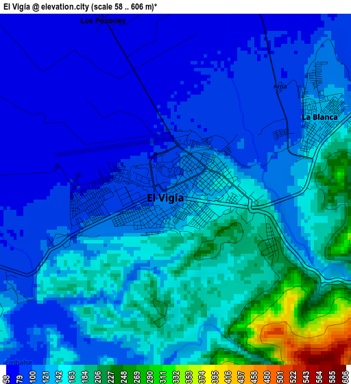
Below is the Elevation map of El Vigía, which displays elevation range with different colors. Scale of the first map is from 58 to 606 m (190 to 1988 ft) with average elevation of 132 meters (=433 ft) [note 1]
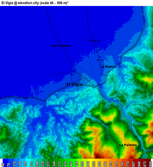
These maps also provides idea of topography and contour of this city, they are displayed at different zoom levels. More info about maps, scale and edge coordinates you can find below images.
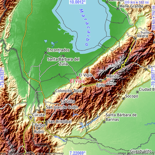
| \ | Map #1 | Map #2 | Topo.Map |
| Scale [m] | 58..606 m | 46..906 m | × |
| Scale [ft] | 190..1988 ft | 151..2972 ft | × |
| Average | 132 m = 433 ft | 177.6 m = 583 ft | × |
| Width | 9.66 km = 6 mi | 19.32 km = 12 mi | 309.2 km = 192.1 mi |
| Height | 9.66 km = 6 mi | 19.32 km = 12 mi | 309.2 km = 192.1 mi |
| ↑Max Latitude | 8.656947° | 8.700389° | 10.0012° |
| Latitude at center | 8.6135° | 8.6135° | 8.6135° |
| ↓Min Latitude | 8.570048° | 8.526591° | 7.22069° |
| ← Min Longitude | -71.700965° | -71.744911° | -73.06327° |
| Longitude center | -71.65702° | -71.65702° | -71.65702° |
| →Max Longitude | -71.613075° | -71.569129° | -70.25077° |
Nearby cities:
Cities around El Vigía sort by population:
• Ejido elevation 1143 m
46.4 km,  99°
99°
• Guaraque 1557 m
51.8 km,  189°
189°
• Bailadores 1710 m
44.2 km,  205°
205°
• Pueblo Nuevo El Chivo 32 m
39.2 km,  7°
7°
• San Simón 1150 m
36.2 km,  216°
216°
• Tovar 1107 m
33.2 km,  198°
198°
• Lagunillas 997 m
31.8 km,  112°
112°
• Santa Elena de Arenales 152 m
31.2 km,  42°
42°
• Zea 1151 m
29.8 km, 207°
• La Azulita 1110 m
25.9 km,  64°
64°
• Santa Cruz de Mora 868 m
23.9 km,  175°
175°
• La Tendida 145 m
22.6 km,  238°
238°
Multilingual:
 En español:
El Vigía elevación 161 m.
 En France:
El Vigía élévation 161 m.
 Auf Deutsch:
El Vigía höhe über dem Meeresspiegel ist 161 m.

Sources and notes:
- [note 1] Map square and city borders are not equal. Map elevation data is calculated only from area inside that square.
- [src 1] Elevation data from geonames database provided with same terms of usage.
- [src 2] The elevation map of El Vigía is generated using elevation data from NASA's 3 arcsec (90m) resolution SRTM data.
- [src 3] Base (background) map © OpenStreetMap contributors tiles are generated by Geofabrik and OpenTopoMap.
Copyright & License:
This El Vigía Elevation Map is licensed under CC BY-SA. You may reuse any part from this page, if you give a proper credit by linking to this URL:
 More info on terms of use page.