Zea elevation
Zea (Mérida, Municipio Zea), Venezuela elevation is 1151 meters and Zea elevation in feet is 3776 ft above sea level [src 1]. Zea is a seat of a second-order administrative division (feature code) with elevation that is 770 meters (2526 ft) bigger than average city elevation in Venezuela.
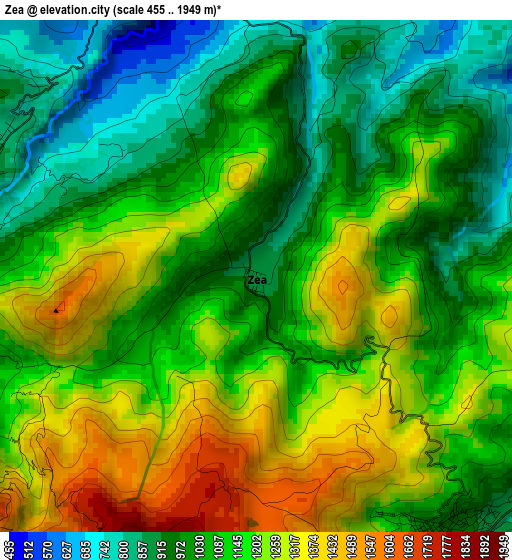
Below is the Elevation map of Zea, which displays elevation range with different colors. Scale of the first map is from 455 to 1949 m (1493 to 6394 ft) with average elevation of 1114.8 meters (=3657 ft) [note 1]
These maps also provides idea of topography and contour of this city, they are displayed at different zoom levels. More info about maps, scale and edge coordinates you can find below images.
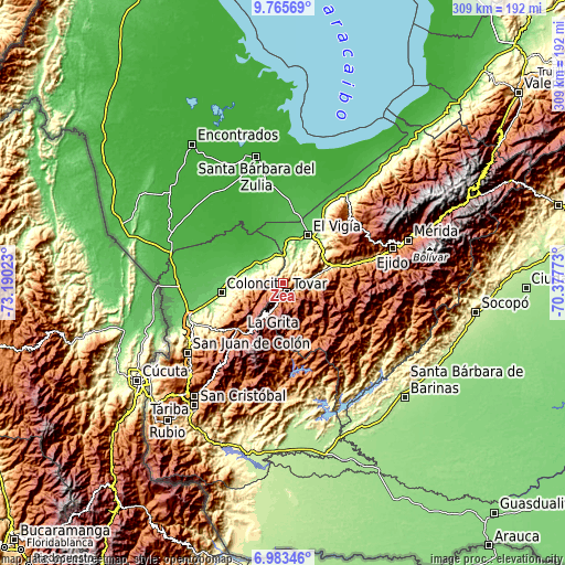
| \ | Map #1 | Topo.Map |
| Scale [m] | 455..1949 m | × |
| Scale [ft] | 1493..6394 ft | × |
| Average | 1114.8 m = 3657 ft | × |
| Width | 9.67 km = 6 mi | 309.4 km = 192.3 mi |
| Height | 9.67 km = 6 mi | 309.4 km = 192.3 mi |
| ↑Max Latitude | 8.420534° | 9.76569° |
| Latitude at center | 8.37706° | 8.37706° |
| ↓Min Latitude | 8.333581° | 6.98346° |
| ← Min Longitude | -71.827925° | -73.19023° |
| Longitude center | -71.78398° | -71.78398° |
| →Max Longitude | -71.740035° | -70.37773° |
Nearby cities:
Cities around Zea sort by population:
• El Vigía elevation 161 m
29.8 km,  27°
27°
• Pregonero 1254 m
39.9 km,  177°
177°
• Santa Ana 1632 m
39 km,  222°
222°
• La Grita 1532 m
34.9 km, 219°
• Coloncito 164 m
33.9 km,  260°
260°
• Umuquena 557 m
33.2 km,  248°
248°
• Guaraque 1557 m
25.4 km,  167°
167°
• Santa Cruz de Mora 868 m
15.9 km,  81°
81°
• La Tendida 145 m
15.4 km,  339°
339°
• Bailadores 1710 m
14.6 km,  199°
199°
• San Simón 1150 m
8 km, 247°
• Tovar 1107 m
6.2 km,  146°
146°
Multilingual:
 En español:
Zea elevación 1151 m.
 En France:
Zea élévation 1151 m.


Sources and notes:
- [note 1] Map square and city borders are not equal. Map elevation data is calculated only from area inside that square.
- [src 1] Elevation data from geonames database provided with same terms of usage.
- [src 2] The elevation map of Zea is generated using elevation data from NASA's 3 arcsec (90m) resolution SRTM data.
- [src 3] Base (background) map © OpenStreetMap contributors tiles are generated by Geofabrik and OpenTopoMap.
Copyright & License:
This Zea Elevation Map is licensed under CC BY-SA. You may reuse any part from this page, if you give a proper credit by linking to this URL:
 More info on terms of use page.