La Grita elevation
La Grita (Táchira, Municipio Jáuregui), Venezuela elevation is 1532 meters and La Grita elevation in feet is 5026 ft above sea level [src 1]. La Grita is a seat of a second-order administrative division (feature code) with elevation that is 1151 meters (3776 ft) bigger than average city elevation in Venezuela.
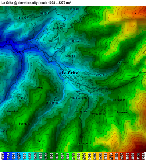
Below is the Elevation map of La Grita, which displays elevation range with different colors. Scale of the first map is from 1028 to 3272 m (3373 to 10735 ft) with average elevation of 1785.4 meters (=5858 ft) [note 1]
These maps also provides idea of topography and contour of this city, they are displayed at different zoom levels. More info about maps, scale and edge coordinates you can find below images.
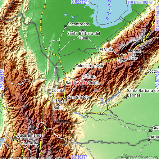
| \ | Map #1 | Topo.Map |
| Scale [m] | 1028..3272 m | × |
| Scale [ft] | 3373..10735 ft | × |
| Average | 1785.4 m = 5858 ft | × |
| Width | 9.67 km = 6 mi | 309.5 km = 192.3 mi |
| Height | 9.67 km = 6 mi | 309.6 km = 192.4 mi |
| ↑Max Latitude | 8.176661° | 9.52272° |
| Latitude at center | 8.13316° | 8.13316° |
| ↓Min Latitude | 8.089654° | 6.73877° |
| ← Min Longitude | -72.027845° | -73.39015° |
| Longitude center | -71.9839° | -71.9839° |
| →Max Longitude | -71.939955° | -70.57765° |
Nearby cities:
Cities around La Grita sort by population:
• San Simón elevation 1150 m
28.2 km,  31°
31°
• Guaraque 1557 m
27.4 km,  85°
85°
• Pregonero 1254 m
27.1 km,  117°
117°
• San José de Bolívar 1577 m
24.6 km,  177°
177°
• Coloncito 164 m
24.3 km,  332°
332°
• Queniquea 1685 m
24.3 km,  187°
187°
• Bailadores 1710 m
21.7 km,  52°
52°
• Las Mesas 484 m
19.8 km,  282°
282°
• Umuquena 557 m
17.3 km, 329°
• El Cobre 2108 m
13.6 km,  216°
216°
• Seboruco 880 m
9.9 km, 277°
• Santa Ana 1632 m
4.5 km,  246°
246°
Multilingual:
 En español:
La Grita elevación 1532 m.
 En France:
La Grita élévation 1532 m.
 Auf Deutsch:
La Grita höhe über dem Meeresspiegel ist 1532 m.

Sources and notes:
- [note 1] Map square and city borders are not equal. Map elevation data is calculated only from area inside that square.
- [src 1] Elevation data from geonames database provided with same terms of usage.
- [src 2] The elevation map of La Grita is generated using elevation data from NASA's 3 arcsec (90m) resolution SRTM data.
- [src 3] Base (background) map © OpenStreetMap contributors tiles are generated by Geofabrik and OpenTopoMap.
Copyright & License:
This La Grita Elevation Map is licensed under CC BY-SA. You may reuse any part from this page, if you give a proper credit by linking to this URL:
 More info on terms of use page.