Santa Cruz de Mora elevation
Santa Cruz de Mora (Mérida, Municipio Antonio Pinto Salinas), Venezuela elevation is 868 meters and Santa Cruz de Mora elevation in feet is 2848 ft above sea level [src 1]. Santa Cruz de Mora is a seat of a second-order administrative division (feature code) with elevation that is 487 meters (1598 ft) bigger than average city elevation in Venezuela.
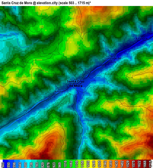
Below is the Elevation map of Santa Cruz de Mora, which displays elevation range with different colors. Scale of the first map is from 503 to 1715 m (1650 to 5627 ft) with average elevation of 962.7 meters (=3158 ft) [note 1]
These maps also provides idea of topography and contour of this city, they are displayed at different zoom levels. More info about maps, scale and edge coordinates you can find below images.
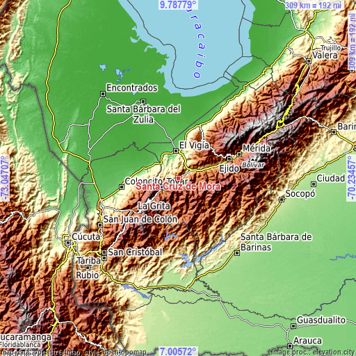
| \ | Map #1 | Topo.Map |
| Scale [m] | 503..1715 m | × |
| Scale [ft] | 1650..5627 ft | × |
| Average | 962.7 m = 3158 ft | × |
| Width | 9.67 km = 6 mi | 309.3 km = 192.2 mi |
| Height | 9.67 km = 6 mi | 309.4 km = 192.3 mi |
| ↑Max Latitude | 8.442722° | 9.78779° |
| Latitude at center | 8.39925° | 8.39925° |
| ↓Min Latitude | 8.355774° | 7.00572° |
| ← Min Longitude | -71.684765° | -73.04707° |
| Longitude center | -71.64082° | -71.64082° |
| →Max Longitude | -71.596875° | -70.23457° |
Nearby cities:
Cities around Santa Cruz de Mora sort by population:
• Ejido elevation 1143 m
46.9 km,  69°
69°
• El Vigía 161 m
23.9 km,  355°
355°
• Pregonero 1254 m
44.5 km,  198°
198°
• La Azulita 1110 m
41.1 km,  31°
31°
• Canaguá 1467 m
36.4 km,  146°
146°
• Lagunillas 997 m
30 km, 67°
• Guaraque 1557 m
29.2 km, 200°
• Bailadores 1710 m
26.2 km,  231°
231°
• La Tendida 145 m
24.2 km,  299°
299°
• San Simón 1150 m
23.8 km,  256°
256°
• Zea 1151 m
15.9 km, 261°
• Tovar 1107 m
14.5 km,  238°
238°
Multilingual:
 En español:
Santa Cruz de Mora elevación 868 m.
 En France:
Santa Cruz de Mora élévation 868 m.
 Auf Deutsch:
Santa Cruz de Mora höhe über dem Meeresspiegel ist 868 m.
 На русском:
Santa Cruz de Mora высота над уровнем моря 868 м
Sources and notes:
- [note 1] Map square and city borders are not equal. Map elevation data is calculated only from area inside that square.
- [src 1] Elevation data from geonames database provided with same terms of usage.
- [src 2] The elevation map of Santa Cruz de Mora is generated using elevation data from NASA's 3 arcsec (90m) resolution SRTM data.
- [src 3] Base (background) map © OpenStreetMap contributors tiles are generated by Geofabrik and OpenTopoMap.
Copyright & License:
This Santa Cruz de Mora Elevation Map is licensed under CC BY-SA. You may reuse any part from this page, if you give a proper credit by linking to this URL:
 More info on terms of use page.