Ejido elevation
Ejido (Mérida, Municipio Campo Elías), Venezuela elevation is 1143 meters and Ejido elevation in feet is 3750 ft above sea level [src 1]. Ejido is a seat of a second-order administrative division (feature code) with elevation that is 762 meters (2500 ft) bigger than average city elevation in Venezuela.
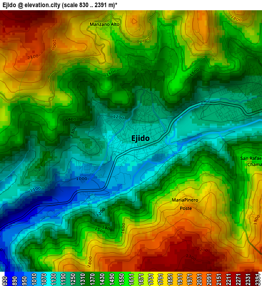
Below is the Elevation map of Ejido, which displays elevation range with different colors. Scale of the first map is from 830 to 2391 m (2723 to 7844 ft) with average elevation of 1519.3 meters (=4985 ft) [note 1]
These maps also provides idea of topography and contour of this city, they are displayed at different zoom levels. More info about maps, scale and edge coordinates you can find below images.
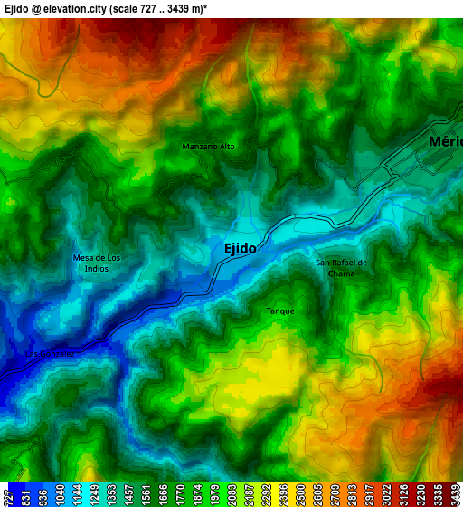
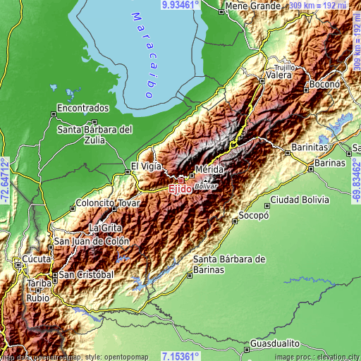
| \ | Map #1 | Map #2 | Topo.Map |
| Scale [m] | 830..2391 m | 727..3439 m | × |
| Scale [ft] | 2723..7844 ft | 2385..11283 ft | × |
| Average | 1519.3 m = 4985 ft | 1879.3 m = 6166 ft | × |
| Width | 9.66 km = 6 mi | 19.33 km = 12 mi | 309.2 km = 192.1 mi |
| Height | 9.66 km = 6 mi | 19.33 km = 12 mi | 309.2 km = 192.1 mi |
| ↑Max Latitude | 8.590105° | 8.633555° | 9.93461° |
| Latitude at center | 8.54665° | 8.54665° | 8.54665° |
| ↓Min Latitude | 8.50319° | 8.459726° | 7.15361° |
| ← Min Longitude | -71.284815° | -71.328761° | -72.64712° |
| Longitude center | -71.24087° | -71.24087° | -71.24087° |
| →Max Longitude | -71.196925° | -71.152979° | -69.83462° |
Nearby cities:
Cities around Ejido sort by population:
• Mérida elevation 1544 m
10.5 km,  62°
62°
• Mucumpiz 2236 m
18.7 km,  140°
140°
• El Vigía 161 m
46.4 km,  279°
279°
• Canaguá 1467 m
52.7 km,  207°
207°
• Tucaní 169 m
47.2 km,  355°
355°
• Santa Cruz de Mora 868 m
46.9 km,  249°
249°
• Mucuchíes 2986 m
41.9 km, 57°
• Santa Elena de Arenales 152 m
39.2 km,  320°
320°
• Aricagua 943 m
37.6 km,  162°
162°
• La Azulita 1110 m
29.1 km,  309°
309°
• Tabay 1687 m
20.2 km, 62°
• Lagunillas 997 m
17 km, 254°
Multilingual:
 En español:
Ejido elevación 1143 m.
 En France:
Ejido élévation 1143 m.


Sources and notes:
- [note 1] Map square and city borders are not equal. Map elevation data is calculated only from area inside that square.
- [src 1] Elevation data from geonames database provided with same terms of usage.
- [src 2] The elevation map of Ejido is generated using elevation data from NASA's 3 arcsec (90m) resolution SRTM data.
- [src 3] Base (background) map © OpenStreetMap contributors tiles are generated by Geofabrik and OpenTopoMap.
Copyright & License:
This Ejido Elevation Map is licensed under CC BY-SA. You may reuse any part from this page, if you give a proper credit by linking to this URL:
 More info on terms of use page.