Ocumare del Tuy elevation
Ocumare del Tuy (Miranda, Municipio Lander), Venezuela elevation is 184 meters and Ocumare del Tuy elevation in feet is 604 ft above sea level [src 1]. Ocumare del Tuy is a seat of a second-order administrative division (feature code) with elevation that is 197 meters (646 ft) smaller than average city elevation in Venezuela.
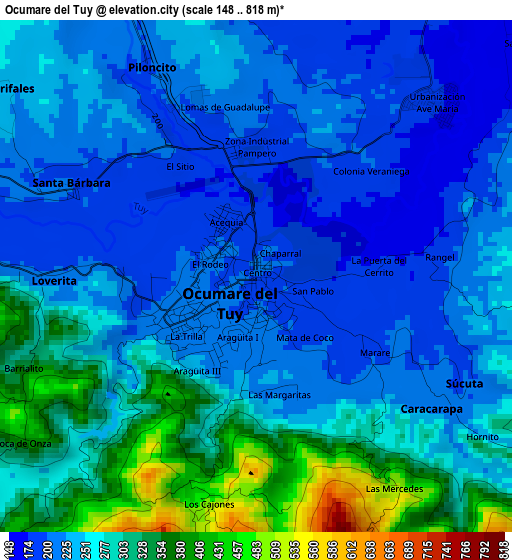
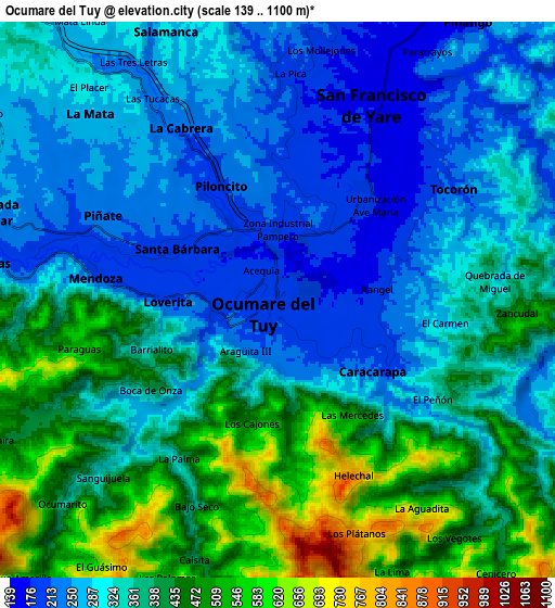
Below is the Elevation map of Ocumare del Tuy, which displays elevation range with different colors. Scale of the first map is from 148 to 818 m (486 to 2684 ft) with average elevation of 256.8 meters (=843 ft) [note 1]
These maps also provides idea of topography and contour of this city, they are displayed at different zoom levels. More info about maps, scale and edge coordinates you can find below images.
| \ | Map #1 | Map #2 | Topo.Map |
| Scale [m] | 148..818 m | 139..1100 m | × |
| Scale [ft] | 486..2684 ft | 456..3609 ft | × |
| Average | 256.8 m = 843 ft | 354.3 m = 1162 ft | × |
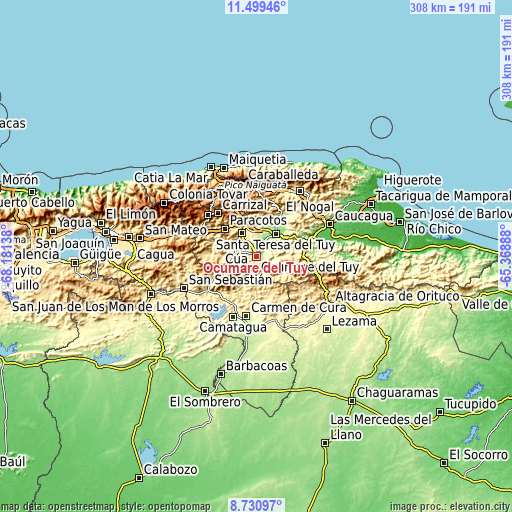
| Width | 9.62 km = 6 mi | 19.24 km = 12 mi | 307.8 km = 191.3 mi |
| Height | 9.62 km = 6 mi | 19.24 km = 12 mi | 307.9 km = 191.3 mi |
| ↑Max Latitude | 10.161459° | 10.204712° | 11.49946° |
| Latitude at center | 10.1182° | 10.1182° | 10.1182° |
| ↓Min Latitude | 10.074935° | 10.031665° | 8.73097° |
| ← Min Longitude | -66.819075° | -66.863021° | -68.18138° |
| Longitude center | -66.77513° | -66.77513° | -66.77513° |
| →Max Longitude | -66.731185° | -66.687239° | -65.36888° |
Nearby cities:
Cities around Ocumare del Tuy sort by population:
• Santa Teresa del Tuy elevation 135 m
17.6 km,  43°
43°
• Baruta 1139 m
36.8 km,  342°
342°
• Cúa 235 m
12.7 km,  292°
292°
• Los Teques 1185 m
38.6 km,  310°
310°
• Charallave 311 m
16.5 km,  326°
326°
• San Antonio de Los Altos 1396 m
35.7 km, 327°
• Caucaguita 1003 m
26.8 km,  353°
353°
• El Hatillo 1222 m
34.5 km, 350°
• Carrizal 1341 m
34.6 km,  318°
318°
• San Casimiro 490 m
29.2 km,  243°
243°
• Santa Lucía 175 m
24.3 km,  31°
31°
• San Francisco de Yare 170 m
7.3 km, 25°
Multilingual:
 En español:
Ocumare, Ocumare del Tuy elevación 184 m.
 En France:
Ocumare del Tuy, Ocumare élévation 184 m.


Sources and notes:
- [note 1] Map square and city borders are not equal. Map elevation data is calculated only from area inside that square.
- [src 1] Elevation data from geonames database provided with same terms of usage.
- [src 2] The elevation map of Ocumare del Tuy is generated using elevation data from NASA's 3 arcsec (90m) resolution SRTM data.
- [src 3] Base (background) map © OpenStreetMap contributors tiles are generated by Geofabrik and OpenTopoMap.
Copyright & License:
This Ocumare del Tuy Elevation Map is licensed under CC BY-SA. You may reuse any part from this page, if you give a proper credit by linking to this URL:
 More info on terms of use page.