Santa Teresa del Tuy elevation
Santa Teresa del Tuy (Miranda), Venezuela elevation is 135 meters and Santa Teresa del Tuy elevation in feet is 443 ft above sea level [src 1]. Santa Teresa del Tuy is a seat of a second-order administrative division (feature code) with elevation that is 246 meters (807 ft) smaller than average city elevation in Venezuela.
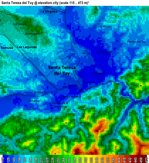
Below is the Elevation map of Santa Teresa del Tuy, which displays elevation range with different colors. Scale of the first map is from 115 to 473 m (377 to 1552 ft) with average elevation of 190.2 meters (=624 ft) [note 1]
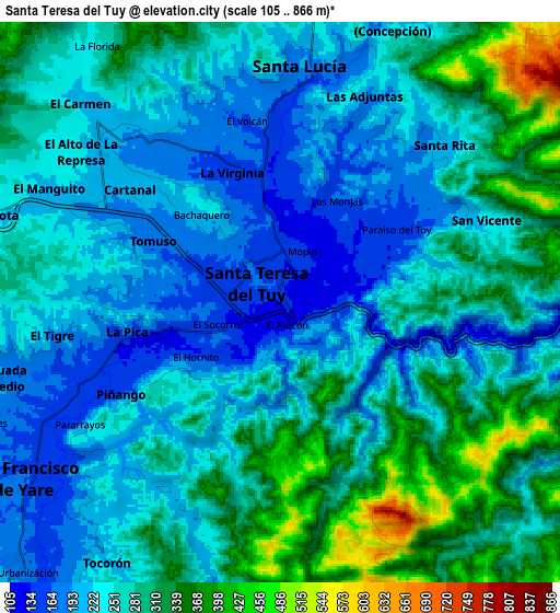
These maps also provides idea of topography and contour of this city, they are displayed at different zoom levels. More info about maps, scale and edge coordinates you can find below images.
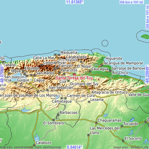
| \ | Map #1 | Map #2 | Topo.Map |
| Scale [m] | 115..473 m | 105..866 m | × |
| Scale [ft] | 377..1552 ft | 344..2841 ft | × |
| Average | 190.2 m = 624 ft | 262.1 m = 860 ft | × |
| Width | 9.62 km = 6 mi | 19.23 km = 11.9 mi | 307.7 km = 191.2 mi |
| Height | 9.62 km = 6 mi | 19.23 km = 11.9 mi | 307.7 km = 191.2 mi |
| ↑Max Latitude | 10.276153° | 10.319391° | 11.61365° |
| Latitude at center | 10.23291° | 10.23291° | 10.23291° |
| ↓Min Latitude | 10.189661° | 10.146406° | 8.84614° |
| ← Min Longitude | -66.708685° | -66.752631° | -68.07099° |
| Longitude center | -66.66474° | -66.66474° | -66.66474° |
| →Max Longitude | -66.620795° | -66.576849° | -65.25849° |
Nearby cities:
Cities around Santa Teresa del Tuy sort by population:
• Petare elevation 914 m
31.3 km,  330°
330°
• Guatire 368 m
30 km,  26°
26°
• Cúa 235 m
25.1 km,  251°
251°
• Guarenas 523 m
26.9 km,  10°
10°
• Ocumare del Tuy 184 m
17.6 km,  223°
223°
• Charallave 311 m
21.1 km,  272°
272°
• Caucaguita 1003 m
20.5 km,  312°
312°
• El Hatillo 1222 m
27.6 km,  320°
320°
• La Dolorita 1034 m
31.3 km, 334°
• Caucagüito 707 m
29.3 km,  344°
344°
• San Francisco de Yare 170 m
10.8 km,  235°
235°
• Santa Lucía 175 m
8 km,  3°
3°
Multilingual:
 En español:
Santa Teresa del Tuy elevación 135 m.
 En France:
Santa Teresa del Tuy élévation 135 m.
 Auf Deutsch:
Santa Teresa del Tuy höhe über dem Meeresspiegel ist 135 m.
 На русском:
Santa Teresa del Tuy высота над уровнем моря 135 м
Sources and notes:
- [note 1] Map square and city borders are not equal. Map elevation data is calculated only from area inside that square.
- [src 1] Elevation data from geonames database provided with same terms of usage.
- [src 2] The elevation map of Santa Teresa del Tuy is generated using elevation data from NASA's 3 arcsec (90m) resolution SRTM data.
- [src 3] Base (background) map © OpenStreetMap contributors tiles are generated by Geofabrik and OpenTopoMap.
Copyright & License:
This Santa Teresa del Tuy Elevation Map is licensed under CC BY-SA. You may reuse any part from this page, if you give a proper credit by linking to this URL:
 More info on terms of use page.