La Dolorita elevation
La Dolorita (Miranda), Venezuela elevation is 1034 meters and La Dolorita elevation in feet is 3392 ft above sea level [src 1]. La Dolorita is a section of populated place (feature code) with elevation that is 653 meters (2142 ft) bigger than average city elevation in Venezuela.
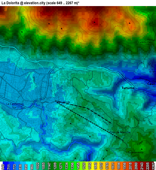
Below is the Elevation map of La Dolorita, which displays elevation range with different colors. Scale of the first map is from 649 to 2267 m (2129 to 7438 ft) with average elevation of 1137.9 meters (=3733 ft) [note 1]
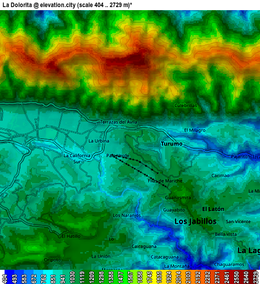
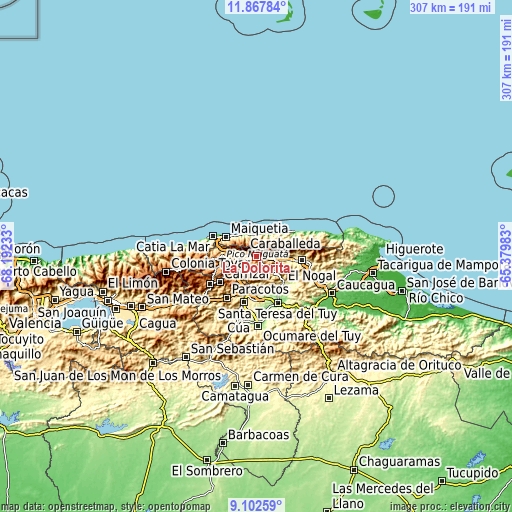
These maps also provides idea of topography and contour of this city, they are displayed at different zoom levels. More info about maps, scale and edge coordinates you can find below images.
| \ | Map #1 | Map #2 | Topo.Map |
| Scale [m] | 649..2267 m | 404..2729 m | × |
| Scale [ft] | 2129..7438 ft | 1325..8953 ft | × |
| Average | 1137.9 m = 3733 ft | 1213.2 m = 3980 ft | × |
| Width | 9.61 km = 6 mi | 19.22 km = 11.9 mi | 307.5 km = 191.1 mi |
| Height | 9.61 km = 6 mi | 19.22 km = 11.9 mi | 307.5 km = 191.1 mi |
| ↑Max Latitude | 10.531508° | 10.57471° | 11.86784° |
| Latitude at center | 10.4883° | 10.4883° | 10.4883° |
| ↓Min Latitude | 10.445086° | 10.401866° | 9.10259° |
| ← Min Longitude | -66.830025° | -66.873971° | -68.19233° |
| Longitude center | -66.78608° | -66.78608° | -66.78608° |
| →Max Longitude | -66.742135° | -66.698189° | -65.37983° |
Nearby cities:
Cities around La Dolorita sort by population:
• Caracas elevation 887 m
10.2 km,  269°
269°
• Petare 914 m
2.7 km,  241°
241°
• Baruta 1139 m
11.5 km, 238°
• El Cafetal 882 m
5.4 km, 241°
• Chacao 887 m
7.4 km,  276°
276°
• Caucaguita 1003 m
14.6 km,  187°
187°
• Los Dos Caminos 876 m
4.7 km, 277°
• El Hatillo 1222 m
8.4 km,  211°
211°
• Caucagüito 707 m
5.3 km,  91°
91°
• Caraballeda 59 m
15.5 km,  332°
332°
• Macuto 142 m
17.8 km,  316°
316°
• Naiguatá 18 m
15.6 km,  19°
19°
Multilingual:
 En español:
La Dolorita elevación 1034 m.
 En France:
La Dolorita élévation 1034 m.
 Auf Deutsch:
La Dolorita höhe über dem Meeresspiegel ist 1034 m.

Sources and notes:
- [note 1] Map square and city borders are not equal. Map elevation data is calculated only from area inside that square.
- [src 1] Elevation data from geonames database provided with same terms of usage.
- [src 2] The elevation map of La Dolorita is generated using elevation data from NASA's 3 arcsec (90m) resolution SRTM data.
- [src 3] Base (background) map © OpenStreetMap contributors tiles are generated by Geofabrik and OpenTopoMap.
Copyright & License:
This La Dolorita Elevation Map is licensed under CC BY-SA. You may reuse any part from this page, if you give a proper credit by linking to this URL:
 More info on terms of use page.