Carrizal elevation
Carrizal (Miranda, Municipio Carrizal), Venezuela elevation is 1341 meters and Carrizal elevation in feet is 4400 ft above sea level [src 1]. Carrizal is a seat of a second-order administrative division (feature code) with elevation that is 960 meters (3150 ft) bigger than average city elevation in Venezuela.
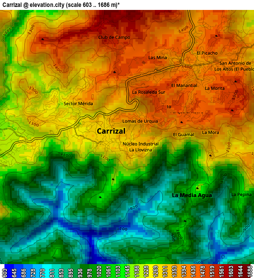
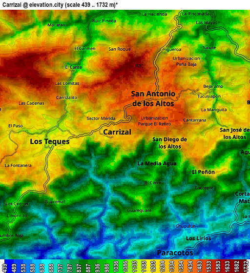
Below is the Elevation map of Carrizal, which displays elevation range with different colors. Scale of the first map is from 603 to 1686 m (1978 to 5531 ft) with average elevation of 1175 meters (=3855 ft) [note 1]
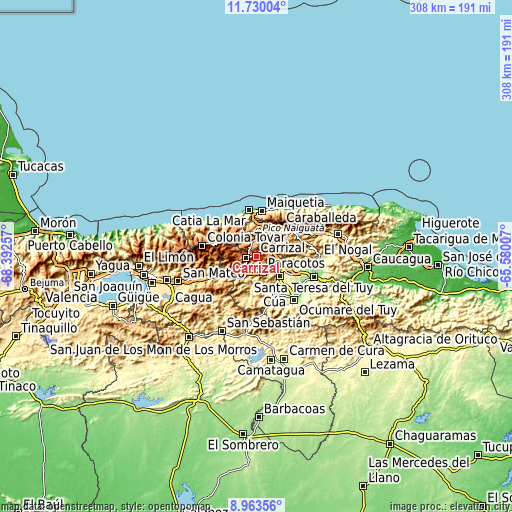
These maps also provides idea of topography and contour of this city, they are displayed at different zoom levels. More info about maps, scale and edge coordinates you can find below images.
| \ | Map #1 | Map #2 | Topo.Map |
| Scale [m] | 603..1686 m | 439..1732 m | × |
| Scale [ft] | 1978..5531 ft | 1440..5682 ft | × |
| Average | 1175 m = 3855 ft | 1081 m = 3547 ft | × |
| Width | 9.61 km = 6 mi | 19.23 km = 11.9 mi | 307.6 km = 191.1 mi |
| Height | 9.61 km = 6 mi | 19.23 km = 11.9 mi | 307.6 km = 191.1 mi |
| ↑Max Latitude | 10.393077° | 10.436299° | 11.73004° |
| Latitude at center | 10.34985° | 10.34985° | 10.34985° |
| ↓Min Latitude | 10.306617° | 10.263378° | 8.96356° |
| ← Min Longitude | -67.030265° | -67.074211° | -68.39257° |
| Longitude center | -66.98632° | -66.98632° | -66.98632° |
| →Max Longitude | -66.942375° | -66.898429° | -65.58007° |
Nearby cities:
Cities around Carrizal sort by population:
• Caracas elevation 887 m
19.3 km,  37°
37°
• Baruta 1139 m
15.3 km,  52°
52°
• Los Teques 1185 m
6.3 km,  264°
264°
• Charallave 311 m
18.5 km,  130°
130°
• El Cafetal 882 m
21.4 km, 53°
• Chacao 887 m
21.8 km, 41°
• San Antonio de Los Altos 1396 m
5.7 km, 41°
• Caucaguita 1003 m
20.1 km,  87°
87°
• El Hatillo 1222 m
19.4 km,  64°
64°
• Las Tejerías 581 m
23.1 km,  242°
242°
• El Junko 1775 m
17.3 km,  322°
322°
• Caricuao 976 m
9.3 km,  2°
2°
Multilingual:
 En español:
Carrizal elevación 1341 m.
 En France:
Carrizal élévation 1341 m.
 Auf Deutsch:
Carrizal höhe über dem Meeresspiegel ist 1341 m.

Sources and notes:
- [note 1] Map square and city borders are not equal. Map elevation data is calculated only from area inside that square.
- [src 1] Elevation data from geonames database provided with same terms of usage.
- [src 2] The elevation map of Carrizal is generated using elevation data from NASA's 3 arcsec (90m) resolution SRTM data.
- [src 3] Base (background) map © OpenStreetMap contributors tiles are generated by Geofabrik and OpenTopoMap.
Copyright & License:
This Carrizal Elevation Map is licensed under CC BY-SA. You may reuse any part from this page, if you give a proper credit by linking to this URL:
 More info on terms of use page.