San Casimiro elevation
San Casimiro (Aragua, Municipio San Casimiro), Venezuela elevation is 490 meters and San Casimiro elevation in feet is 1608 ft above sea level [src 1]. San Casimiro is a seat of a second-order administrative division (feature code) with elevation that is 109 meters (358 ft) bigger than average city elevation in Venezuela.
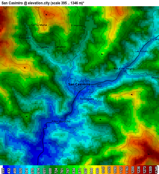
Below is the Elevation map of San Casimiro, which displays elevation range with different colors. Scale of the first map is from 395 to 1346 m (1296 to 4416 ft) with average elevation of 723.2 meters (=2373 ft) [note 1]
These maps also provides idea of topography and contour of this city, they are displayed at different zoom levels. More info about maps, scale and edge coordinates you can find below images.
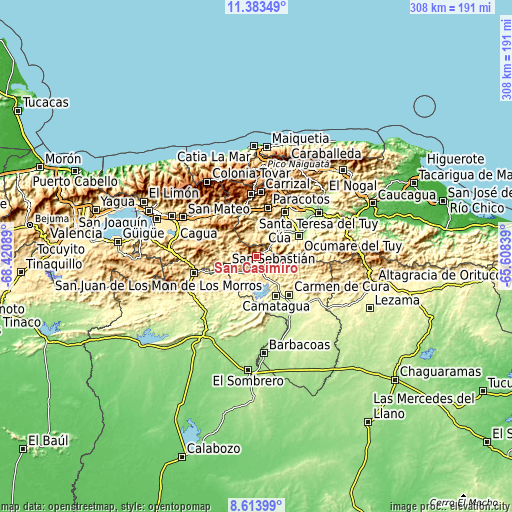
| \ | Map #1 | Topo.Map |
| Scale [m] | 395..1346 m | × |
| Scale [ft] | 1296..4416 ft | × |
| Average | 723.2 m = 2373 ft | × |
| Width | 9.62 km = 6 mi | 307.9 km = 191.3 mi |
| Height | 9.62 km = 6 mi | 308 km = 191.4 mi |
| ↑Max Latitude | 10.044965° | 11.38349° |
| Latitude at center | 10.00169° | 10.00169° |
| ↓Min Latitude | 9.95841° | 8.61399° |
| ← Min Longitude | -67.058585° | -68.42089° |
| Longitude center | -67.01464° | -67.01464° |
| →Max Longitude | -66.970695° | -65.60839° |
Nearby cities:
Cities around San Casimiro sort by population:
• Cúa elevation 235 m
23 km,  38°
38°
• Ocumare del Tuy 184 m
29.2 km,  63°
63°
• Los Teques 1185 m
38.2 km,  355°
355°
• Charallave 311 m
31.8 km,  32°
32°
• San Juan de los Morros 433 m
38.5 km,  254°
254°
• La Victoria 612 m
42.7 km,  305°
305°
• Carrizal 1341 m
38.8 km,  4°
4°
• Las Tejerías 581 m
33 km,  328°
328°
• El Consejo 589 m
38.4 km, 313°
• San Francisco de Yare 170 m
35.3 km, 56°
• Camatagua 250 m
26.6 km,  153°
153°
• San Sebastián 359 m
18.5 km, 248°
Multilingual:
 En español:
San Casimiro elevación 490 m.
 En France:
San Casimiro élévation 490 m.
 Auf Deutsch:
San Casimiro höhe über dem Meeresspiegel ist 490 m.

Sources and notes:
- [note 1] Map square and city borders are not equal. Map elevation data is calculated only from area inside that square.
- [src 1] Elevation data from geonames database provided with same terms of usage.
- [src 2] The elevation map of San Casimiro is generated using elevation data from NASA's 3 arcsec (90m) resolution SRTM data.
- [src 3] Base (background) map © OpenStreetMap contributors tiles are generated by Geofabrik and OpenTopoMap.
Copyright & License:
This San Casimiro Elevation Map is licensed under CC BY-SA. You may reuse any part from this page, if you give a proper credit by linking to this URL:
 More info on terms of use page.