Lackland Air Force Base elevation
Lackland Air Force Base (Texas, Bexar County), United States elevation is 230 meters and Lackland Air Force Base elevation in feet is 755 ft above sea level [src 1]. Lackland Air Force Base is a populated place (feature code) with elevation that is 49 meters (161 ft) smaller than average city elevation in United States.
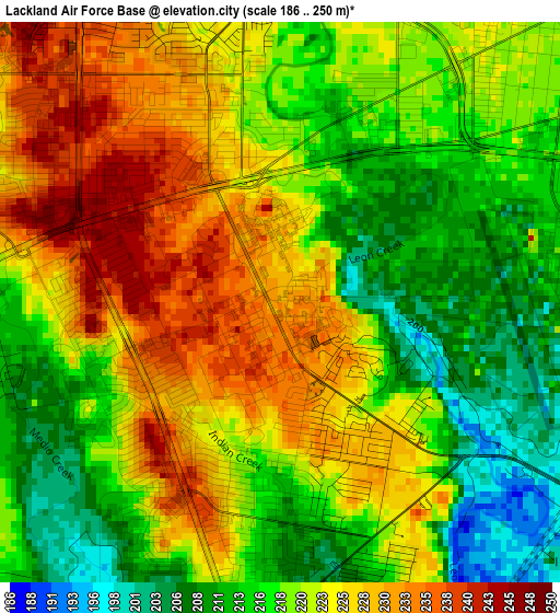
Below is the Elevation map of Lackland Air Force Base, which displays elevation range with different colors. Scale of the first map is from 186 to 250 m (610 to 820 ft) with average elevation of 220.8 meters (=724 ft) [note 1]
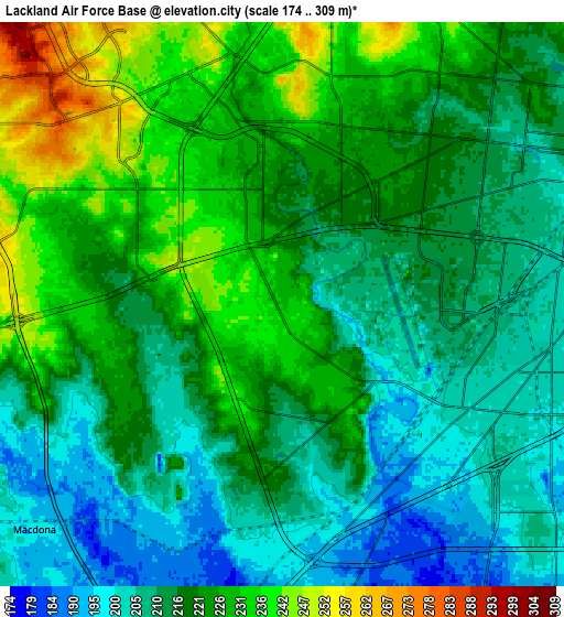
These maps also provides idea of topography and contour of this city, they are displayed at different zoom levels. More info about maps, scale and edge coordinates you can find below images.
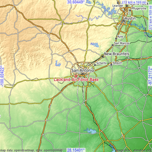
| \ | Map #1 | Map #2 | Topo.Map |
| Scale [m] | 186..250 m | 174..309 m | × |
| Scale [ft] | 610..820 ft | 571..1014 ft | × |
| Average | 220.8 m = 724 ft | 217.8 m = 715 ft | × |
| Width | 8.52 km = 5.3 mi | 17.03 km = 10.6 mi | 272.5 km = 169.3 mi |
| Height | 8.52 km = 5.3 mi | 17.03 km = 10.6 mi | 272.5 km = 169.3 mi |
| ↑Max Latitude | 29.424914° | 29.463183° | 30.60449° |
| Latitude at center | 29.38663° | 29.38663° | 29.38663° |
| ↓Min Latitude | 29.348332° | 29.31002° | 28.15401° |
| ← Min Longitude | -98.661915° | -98.705861° | -100.02422° |
| Longitude center | -98.61797° | -98.61797° | -98.61797° |
| →Max Longitude | -98.574025° | -98.530079° | -97.21172° |
Nearby cities:
Cities around Lackland Air Force Base sort by population:
• San Antonio elevation 202 m
12.7 km,  70°
70°
• Leon Valley 252 m
12.1 km,  359°
359°
• Helotes 319 m
22.4 km,  341°
341°
• Alamo Heights 248 m
18.3 km,  53°
53°
• Terrell Hills 249 m
18.9 km,  58°
58°
• Castle Hills 260 m
18.1 km,  32°
32°
• Shavano Park 302 m
22.9 km,  16°
16°
• Balcones Heights 258 m
13 km, 29°
• Olmos Park 248 m
16.3 km, 50°
• Somerset 199 m
18.2 km,  192°
192°
• Von Ormy 182 m
11.1 km, 193°
• La Coste 222 m
20.4 km,  245°
245°
Multilingual:
 En español:
Lackland Air Force Base elevación 230 m.
 En France:
Lackland Air Force Base élévation 230 m.
 Auf Deutsch:
Lackland Air Force Base höhe über dem Meeresspiegel ist 230 m.
 На русском:
Lackland Air Force Base высота над уровнем моря 230 м
Sources and notes:
- [note 1] Map square and city borders are not equal. Map elevation data is calculated only from area inside that square.
- [src 1] Elevation data from geonames database provided with same terms of usage.
- [src 2] The elevation map of Lackland Air Force Base is generated using elevation data from NASA's 3 arcsec (90m) resolution SRTM data.
- [src 3] Base (background) map © OpenStreetMap contributors tiles are generated by Geofabrik and OpenTopoMap.
Copyright & License:
This Lackland Air Force Base Elevation Map is licensed under CC BY-SA. You may reuse any part from this page, if you give a proper credit by linking to this URL:
 More info on terms of use page.