Castle Hills elevation
Castle Hills (Texas, Bexar County), United States elevation is 260 meters and Castle Hills elevation in feet is 853 ft above sea level [src 1]. Castle Hills is a populated place (feature code) with elevation that is 19 meters (62 ft) smaller than average city elevation in United States.
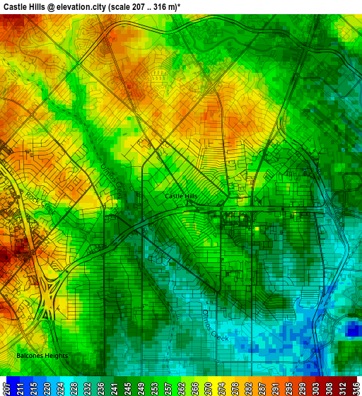
Below is the Elevation map of Castle Hills, which displays elevation range with different colors. Scale of the first map is from 207 to 316 m (679 to 1037 ft) with average elevation of 256 meters (=840 ft) [note 1]
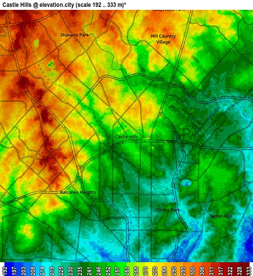
These maps also provides idea of topography and contour of this city, they are displayed at different zoom levels. More info about maps, scale and edge coordinates you can find below images.
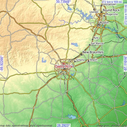
| \ | Map #1 | Map #2 | Topo.Map |
| Scale [m] | 207..316 m | 192..333 m | × |
| Scale [ft] | 679..1037 ft | 630..1093 ft | × |
| Average | 256 m = 840 ft | 258.4 m = 848 ft | × |
| Width | 8.5 km = 5.3 mi | 17.01 km = 10.6 mi | 272.1 km = 169.1 mi |
| Height | 8.5 km = 5.3 mi | 17.01 km = 10.6 mi | 272.1 km = 169.1 mi |
| ↑Max Latitude | 29.561522° | 29.59974° | 30.73948° |
| Latitude at center | 29.52329° | 29.52329° | 29.52329° |
| ↓Min Latitude | 29.485044° | 29.446783° | 28.2923° |
| ← Min Longitude | -98.560355° | -98.604301° | -99.92266° |
| Longitude center | -98.51641° | -98.51641° | -98.51641° |
| →Max Longitude | -98.472465° | -98.428519° | -97.11016° |
Nearby cities:
Cities around Castle Hills sort by population:
• San Antonio elevation 202 m
11.2 km,  168°
168°
• Leon Valley 252 m
10.4 km,  252°
252°
• Helotes 319 m
17.8 km,  289°
289°
• Kirby 214 m
14.3 km,  117°
117°
• Alamo Heights 248 m
6.5 km,  131°
131°
• Windcrest 245 m
13.2 km,  93°
93°
• Terrell Hills 249 m
8.3 km, 130°
• Shavano Park 302 m
7.7 km,  333°
333°
• Hollywood Park 301 m
9 km,  18°
18°
• Balcones Heights 258 m
5.2 km,  221°
221°
• Olmos Park 248 m
5.7 km,  150°
150°
• Hill Country Village 291 m
7 km, 20°
Multilingual:
 En español:
Castle Hills elevación 260 m.
 En France:
Castle Hills élévation 260 m.
 Auf Deutsch:
Castle Hills höhe über dem Meeresspiegel ist 260 m.

Sources and notes:
- [note 1] Map square and city borders are not equal. Map elevation data is calculated only from area inside that square.
- [src 1] Elevation data from geonames database provided with same terms of usage.
- [src 2] The elevation map of Castle Hills is generated using elevation data from NASA's 3 arcsec (90m) resolution SRTM data.
- [src 3] Base (background) map © OpenStreetMap contributors tiles are generated by Geofabrik and OpenTopoMap.
Copyright & License:
This Castle Hills Elevation Map is licensed under CC BY-SA. You may reuse any part from this page, if you give a proper credit by linking to this URL:
 More info on terms of use page.