San Antonio elevation
San Antonio (Texas, Bexar County), United States elevation is 202 meters and San Antonio elevation in feet is 663 ft above sea level [src 1]. San Antonio is a seat of a second-order administrative division (feature code) with elevation that is 77 meters (253 ft) smaller than average city elevation in United States.
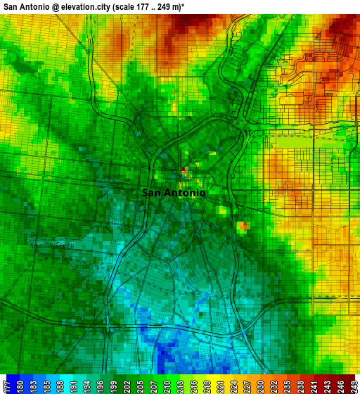
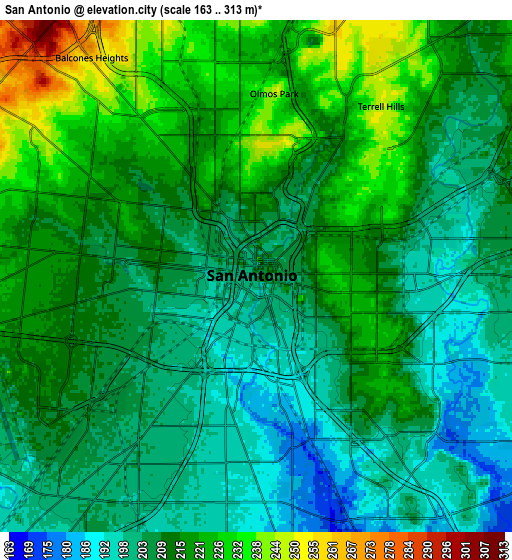
Below is the Elevation map of San Antonio, which displays elevation range with different colors. Scale of the first map is from 177 to 249 m (581 to 817 ft) with average elevation of 208.2 meters (=683 ft) [note 1]
These maps also provides idea of topography and contour of this city, they are displayed at different zoom levels. More info about maps, scale and edge coordinates you can find below images.
| \ | Map #1 | Map #2 | Topo.Map |
| Scale [m] | 177..249 m | 163..313 m | × |
| Scale [ft] | 581..817 ft | 535..1027 ft | × |
| Average | 208.2 m = 683 ft | 211.5 m = 694 ft | × |
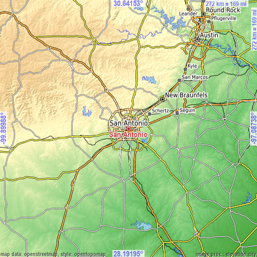
| Width | 8.51 km = 5.3 mi | 17.02 km = 10.6 mi | 272.4 km = 169.3 mi |
| Height | 8.51 km = 5.3 mi | 17.02 km = 10.6 mi | 272.4 km = 169.3 mi |
| ↑Max Latitude | 29.462389° | 29.500644° | 30.64153° |
| Latitude at center | 29.42412° | 29.42412° | 29.42412° |
| ↓Min Latitude | 29.385836° | 29.347538° | 28.19195° |
| ← Min Longitude | -98.537575° | -98.581521° | -99.89988° |
| Longitude center | -98.49363° | -98.49363° | -98.49363° |
| →Max Longitude | -98.449685° | -98.405739° | -97.08738° |
Nearby cities:
Cities around San Antonio sort by population:
• Leon Valley elevation 252 m
14.5 km,  303°
303°
• Lackland Air Force Base 230 m
12.7 km,  250°
250°
• Kirby 214 m
11.3 km,  67°
67°
• Alamo Heights 248 m
7.3 km,  21°
21°
• Windcrest 245 m
15 km,  47°
47°
• Terrell Hills 249 m
7 km,  36°
36°
• Castle Hills 260 m
11.2 km,  348°
348°
• Shavano Park 302 m
18.8 km,  342°
342°
• Balcones Heights 258 m
9.1 km,  321°
321°
• Olmos Park 248 m
6.1 km,  5°
5°
• China Grove 205 m
14.6 km,  105°
105°
• Hill Country Village 291 m
17.6 km,  0°
0°
Multilingual:
 En español:
San Antonio elevación 202 m.
 En France:
San Antonio élévation 202 m.
 Auf Deutsch:
San Antonio höhe über dem Meeresspiegel ist 202 m.

Sources and notes:
- [note 1] Map square and city borders are not equal. Map elevation data is calculated only from area inside that square.
- [src 1] Elevation data from geonames database provided with same terms of usage.
- [src 2] The elevation map of San Antonio is generated using elevation data from NASA's 3 arcsec (90m) resolution SRTM data.
- [src 3] Base (background) map © OpenStreetMap contributors tiles are generated by Geofabrik and OpenTopoMap.
Copyright & License:
This San Antonio Elevation Map is licensed under CC BY-SA. You may reuse any part from this page, if you give a proper credit by linking to this URL:
 More info on terms of use page.