Mount Gay-Shamrock elevation
Mount Gay-Shamrock (West Virginia, Logan County), United States elevation is 327 meters and Mount Gay-Shamrock elevation in feet is 1073 ft above sea level [src 1]. Mount Gay-Shamrock is a populated place (feature code) with elevation that is 48 meters (157 ft) bigger than average city elevation in United States.
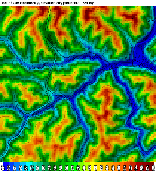
Below is the Elevation map of Mount Gay-Shamrock, which displays elevation range with different colors. Scale of the first map is from 197 to 589 m (646 to 1932 ft) with average elevation of 359.2 meters (=1178 ft) [note 1]
These maps also provides idea of topography and contour of this city, they are displayed at different zoom levels. More info about maps, scale and edge coordinates you can find below images.
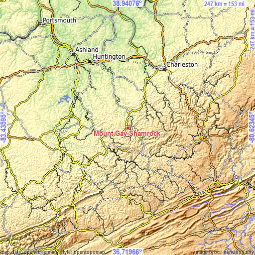
| \ | Map #1 | Topo.Map |
| Scale [m] | 197..589 m | × |
| Scale [ft] | 646..1932 ft | × |
| Average | 359.2 m = 1178 ft | × |
| Width | 7.72 km = 4.8 mi | 247 km = 153.5 mi |
| Height | 7.72 km = 4.8 mi | 247 km = 153.5 mi |
| ↑Max Latitude | 37.873267° | 38.94076° |
| Latitude at center | 37.83857° | 37.83857° |
| ↓Min Latitude | 37.803856° | 36.71966° |
| ← Min Longitude | -82.073645° | -83.43595° |
| Longitude center | -82.0297° | -82.0297° |
| →Max Longitude | -81.985755° | -80.62345° |
Nearby cities:
Cities around Mount Gay-Shamrock sort by population:
• Williamson elevation 200 m
28.4 km,  229°
229°
• Madison 221 m
31.4 km,  35°
35°
• Alum Creek 190 m
53.6 km,  21°
21°
• Mallory 244 m
20.7 km,  125°
125°
• Logan 204 m
3.4 km,  70°
70°
• Wayne 214 m
55.8 km,  319°
319°
• Oceana 380 m
39.2 km,  114°
114°
• Chapmanville 197 m
15.1 km,  4°
4°
• Hamlin 199 m
49.4 km,  352°
352°
• Gilbert Creek 346 m
31.5 km,  157°
157°
• Inez 198 m
44.8 km,  273°
273°
• Pineville 396 m
51.8 km,  123°
123°
Multilingual:
 En español:
Mount Gay-Shamrock elevación 327 m.
 En France:
Mount Gay-Shamrock élévation 327 m.
 Auf Deutsch:
Mount Gay-Shamrock höhe über dem Meeresspiegel ist 327 m.
 На русском:
Mount Gay-Shamrock высота над уровнем моря 327 м
Sources and notes:
- [note 1] Map square and city borders are not equal. Map elevation data is calculated only from area inside that square.
- [src 1] Elevation data from geonames database provided with same terms of usage.
- [src 2] The elevation map of Mount Gay-Shamrock is generated using elevation data from NASA's 3 arcsec (90m) resolution SRTM data.
- [src 3] Base (background) map © OpenStreetMap contributors tiles are generated by Geofabrik and OpenTopoMap.
Copyright & License:
This Mount Gay-Shamrock Elevation Map is licensed under CC BY-SA. You may reuse any part from this page, if you give a proper credit by linking to this URL:
 More info on terms of use page.