Logan elevation
Logan (West Virginia, Logan County), United States elevation is 204 meters and Logan elevation in feet is 669 ft above sea level [src 1]. Logan is a seat of a second-order administrative division (feature code) with elevation that is 75 meters (246 ft) smaller than average city elevation in United States.
Below is the Elevation map of Logan, which displays elevation range with different colors. Scale of the first map is from 195 to 621 m (640 to 2037 ft) with average elevation of 365.1 meters (=1198 ft) [note 1]
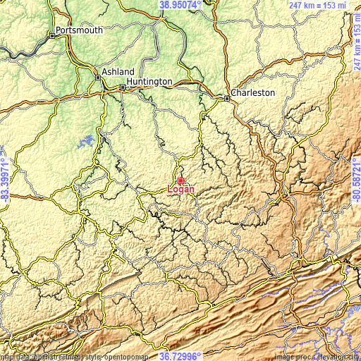
These maps also provides idea of topography and contour of this city, they are displayed at different zoom levels. More info about maps, scale and edge coordinates you can find below images.
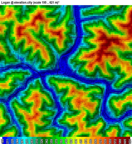
| \ | Map #1 | Topo.Map |
| Scale [m] | 195..621 m | × |
| Scale [ft] | 640..2037 ft | × |
| Average | 365.1 m = 1198 ft | × |
| Width | 7.72 km = 4.8 mi | 246.9 km = 153.4 mi |
| Height | 7.72 km = 4.8 mi | 246.9 km = 153.4 mi |
| ↑Max Latitude | 37.883403° | 38.95074° |
| Latitude at center | 37.84871° | 37.84871° |
| ↓Min Latitude | 37.814001° | 36.72996° |
| ← Min Longitude | -82.037405° | -83.39971° |
| Longitude center | -81.99346° | -81.99346° |
| →Max Longitude | -81.949515° | -80.58721° |
Nearby cities:
Cities around Logan sort by population:
• Tornado elevation 187 m
56.5 km,  13°
13°
• Williamson 200 m
31.6 km,  232°
232°
• Madison 221 m
28.7 km,  32°
32°
• Mount Gay-Shamrock 327 m
3.4 km,  250°
250°
• Alum Creek 190 m
51.4 km,  18°
18°
• Mallory 244 m
19 km,  133°
133°
• Oceana 380 m
36.8 km,  118°
118°
• Chapmanville 197 m
14.1 km,  351°
351°
• Hamlin 199 m
48.8 km, 348°
• Gilbert Creek 346 m
31.5 km,  164°
164°
• Inez 198 m
47.9 km,  272°
272°
• Pineville 396 m
49.8 km, 126°
Multilingual:
 En español:
Logan elevación 204 m.
 En France:
Logan élévation 204 m.


Sources and notes:
- [note 1] Map square and city borders are not equal. Map elevation data is calculated only from area inside that square.
- [src 1] Elevation data from geonames database provided with same terms of usage.
- [src 2] The elevation map of Logan is generated using elevation data from NASA's 3 arcsec (90m) resolution SRTM data.
- [src 3] Base (background) map © OpenStreetMap contributors tiles are generated by Geofabrik and OpenTopoMap.
Copyright & License:
This Logan Elevation Map is licensed under CC BY-SA. You may reuse any part from this page, if you give a proper credit by linking to this URL:
 More info on terms of use page.