Chehalis elevation
Chehalis (Washington, Lewis County), United States elevation is 68 meters and Chehalis elevation in feet is 223 ft above sea level [src 1]. Chehalis is a seat of a second-order administrative division (feature code) with elevation that is 211 meters (692 ft) smaller than average city elevation in United States.
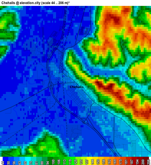
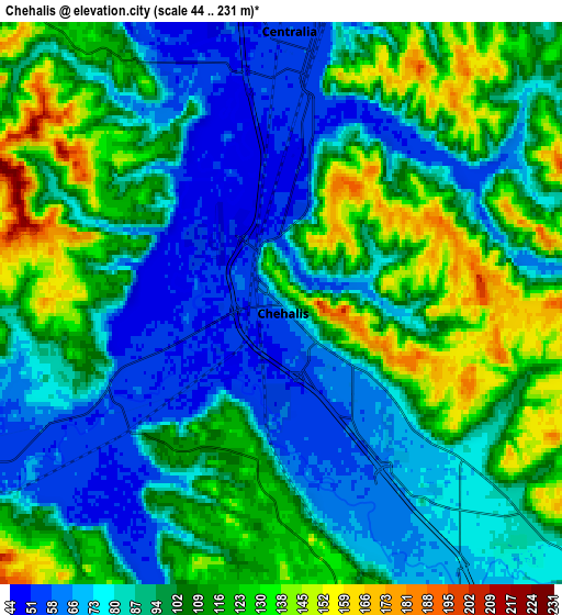
Below is the Elevation map of Chehalis, which displays elevation range with different colors. Scale of the first map is from 44 to 206 m (144 to 676 ft) with average elevation of 80.9 meters (=265 ft) [note 1]
These maps also provides idea of topography and contour of this city, they are displayed at different zoom levels. More info about maps, scale and edge coordinates you can find below images.
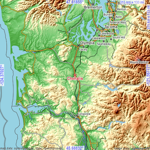
| \ | Map #1 | Map #2 | Topo.Map |
| Scale [m] | 44..206 m | 44..231 m | × |
| Scale [ft] | 144..676 ft | 144..758 ft | × |
| Average | 80.9 m = 265 ft | 97.3 m = 319 ft | × |
| Width | 6.71 km = 4.2 mi | 13.41 km = 8.3 mi | 214.6 km = 133.3 mi |
| Height | 6.71 km = 4.2 mi | 13.41 km = 8.3 mi | 214.6 km = 133.3 mi |
| ↑Max Latitude | 46.692201° | 46.722336° | 47.61855° |
| Latitude at center | 46.66205° | 46.66205° | 46.66205° |
| ↓Min Latitude | 46.631882° | 46.601697° | 45.68832° |
| ← Min Longitude | -123.007965° | -123.051911° | -124.37027° |
| Longitude center | -122.96402° | -122.96402° | -122.96402° |
| →Max Longitude | -122.920075° | -122.876129° | -121.55777° |
Nearby cities:
Cities around Chehalis sort by population:
• Olympia elevation 32 m
42.1 km,  6°
6°
• Lacey 62 m
42.7 km, 14°
• Tumwater 53 m
38.6 km, 6°
• Centralia 57 m
6.1 km, 7°
• Yelm 107 m
41.4 km,  41°
41°
• Grand Mound 47 m
14.4 km,  345°
345°
• Rochester 42 m
20.4 km,  330°
330°
• Rainier 130 m
32.7 km, 39°
• Fords Prairie 53 m
8.3 km, 346°
• Napavine 134 m
10.6 km,  156°
156°
• Tenino 86 m
23.2 km,  21°
21°
• Winlock 93 m
19.1 km,  174°
174°
Multilingual:
 En español:
Chehalis elevación 68 m.
 En France:
Chehalis élévation 68 m.


Sources and notes:
- [note 1] Map square and city borders are not equal. Map elevation data is calculated only from area inside that square.
- [src 1] Elevation data from geonames database provided with same terms of usage.
- [src 2] The elevation map of Chehalis is generated using elevation data from NASA's 3 arcsec (90m) resolution SRTM data.
- [src 3] Base (background) map © OpenStreetMap contributors tiles are generated by Geofabrik and OpenTopoMap.
Copyright & License:
This Chehalis Elevation Map is licensed under CC BY-SA. You may reuse any part from this page, if you give a proper credit by linking to this URL:
 More info on terms of use page.