Winlock elevation
Winlock (Washington, Lewis County), United States elevation is 93 meters and Winlock elevation in feet is 305 ft above sea level [src 1]. Winlock is a populated place (feature code) with elevation that is 186 meters (610 ft) smaller than average city elevation in United States.
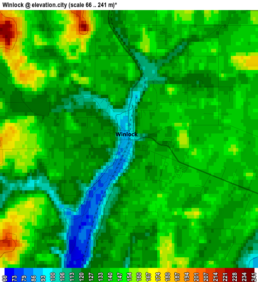
Below is the Elevation map of Winlock, which displays elevation range with different colors. Scale of the first map is from 66 to 241 m (217 to 791 ft) with average elevation of 136 meters (=446 ft) [note 1]
These maps also provides idea of topography and contour of this city, they are displayed at different zoom levels. More info about maps, scale and edge coordinates you can find below images.
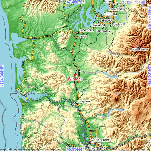
| \ | Map #1 | Topo.Map |
| Scale [m] | 66..241 m | × |
| Scale [ft] | 217..791 ft | × |
| Average | 136 m = 446 ft | × |
| Width | 6.73 km = 4.2 mi | 215.3 km = 133.8 mi |
| Height | 6.73 km = 4.2 mi | 215.3 km = 133.8 mi |
| ↑Max Latitude | 46.521466° | 47.45076° |
| Latitude at center | 46.49122° | 46.49122° |
| ↓Min Latitude | 46.460957° | 45.51444° |
| ← Min Longitude | -122.981845° | -124.34415° |
| Longitude center | -122.9379° | -122.9379° |
| →Max Longitude | -122.893955° | -121.53165° |
Nearby cities:
Cities around Winlock sort by population:
• Longview elevation 10 m
39.3 km,  180°
180°
• Centralia 57 m
25 km,  357°
357°
• Kelso 21 m
38.4 km, 176°
• Chehalis 68 m
19.1 km,  354°
354°
• West Side Highway 15 m
34.2 km, 177°
• Longview Heights 276 m
34.6 km, 182°
• Grand Mound 47 m
33.5 km, 350°
• West Longview 2 m
36.3 km,  187°
187°
• Rochester 42 m
38.7 km,  341°
341°
• Castle Rock 17 m
24.1 km,  174°
174°
• Fords Prairie 53 m
27.4 km, 351°
• Napavine 134 m
9.5 km,  13°
13°
Multilingual:
 En español:
Winlock elevación 93 m.
 En France:
Winlock élévation 93 m.


Sources and notes:
- [note 1] Map square and city borders are not equal. Map elevation data is calculated only from area inside that square.
- [src 1] Elevation data from geonames database provided with same terms of usage.
- [src 2] The elevation map of Winlock is generated using elevation data from NASA's 3 arcsec (90m) resolution SRTM data.
- [src 3] Base (background) map © OpenStreetMap contributors tiles are generated by Geofabrik and OpenTopoMap.
Copyright & License:
This Winlock Elevation Map is licensed under CC BY-SA. You may reuse any part from this page, if you give a proper credit by linking to this URL:
 More info on terms of use page.