Lacey elevation
Lacey (Washington, Thurston County), United States elevation is 62 meters and Lacey elevation in feet is 203 ft above sea level [src 1]. Lacey is a populated place (feature code) with elevation that is 217 meters (712 ft) smaller than average city elevation in United States.
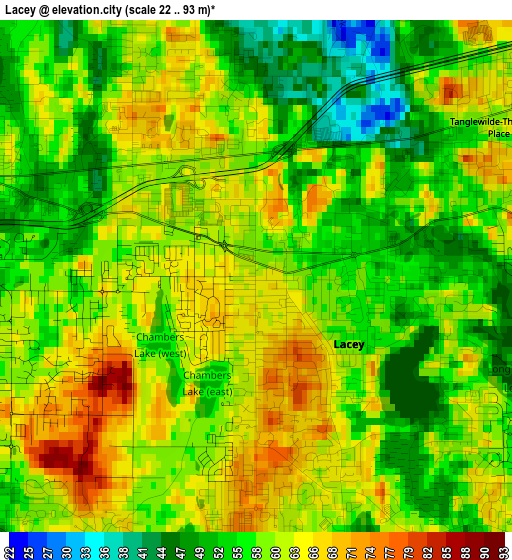
Below is the Elevation map of Lacey, which displays elevation range with different colors. Scale of the first map is from 22 to 93 m (72 to 305 ft) with average elevation of 58.9 meters (=193 ft) [note 1]
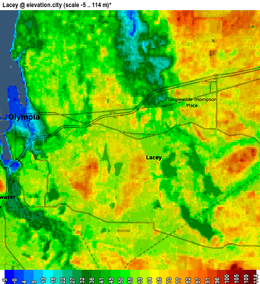
These maps also provides idea of topography and contour of this city, they are displayed at different zoom levels. More info about maps, scale and edge coordinates you can find below images.
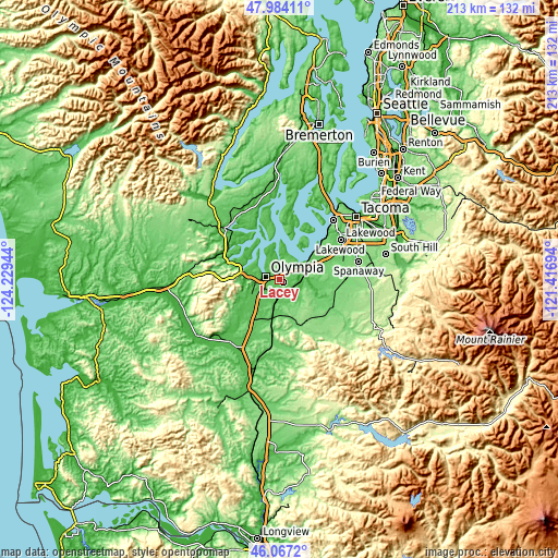
| \ | Map #1 | Map #2 | Topo.Map |
| Scale [m] | 22..93 m | -5..114 m | × |
| Scale [ft] | 72..305 ft | -16..374 ft | × |
| Average | 58.9 m = 193 ft | 56.8 m = 186 ft | × |
| Width | 6.66 km = 4.1 mi | 13.32 km = 8.3 mi | 213.1 km = 132.4 mi |
| Height | 6.66 km = 4.1 mi | 13.32 km = 8.3 mi | 213.1 km = 132.4 mi |
| ↑Max Latitude | 47.064203° | 47.094129° | 47.98411° |
| Latitude at center | 47.03426° | 47.03426° | 47.03426° |
| ↓Min Latitude | 47.0043° | 46.974324° | 46.0672° |
| ← Min Longitude | -122.867135° | -122.911081° | -124.22944° |
| Longitude center | -122.82319° | -122.82319° | -122.82319° |
| →Max Longitude | -122.779245° | -122.735299° | -121.41694° |
Nearby cities:
Cities around Lacey sort by population:
• Olympia elevation 32 m
5.9 km,  273°
273°
• Tumwater 53 m
7.2 km,  245°
245°
• Joint Base Lewis McChord 82 m
20.4 km,  66°
66°
• DuPont 73 m
16.1 km,  64°
64°
• Yelm 107 m
19.4 km,  121°
121°
• Tanglewilde-Thompson Place 63 m
3.7 km, 59°
• Tanglewilde 62 m
3.6 km, 58°
• Longbranch 7 m
20.1 km,  14°
14°
• North Yelm 91 m
18.5 km, 115°
• North Fort Lewis 84 m
19.8 km, 60°
• Rainier 130 m
19.2 km,  147°
147°
• Tenino 86 m
19.9 km,  186°
186°
Multilingual:
 En español:
Lacey elevación 62 m.
 En France:
Lacey élévation 62 m.


Sources and notes:
- [note 1] Map square and city borders are not equal. Map elevation data is calculated only from area inside that square.
- [src 1] Elevation data from geonames database provided with same terms of usage.
- [src 2] The elevation map of Lacey is generated using elevation data from NASA's 3 arcsec (90m) resolution SRTM data.
- [src 3] Base (background) map © OpenStreetMap contributors tiles are generated by Geofabrik and OpenTopoMap.
Copyright & License:
This Lacey Elevation Map is licensed under CC BY-SA. You may reuse any part from this page, if you give a proper credit by linking to this URL:
 More info on terms of use page.