DuPont elevation
DuPont (Washington, Pierce County), United States elevation is 73 meters and DuPont elevation in feet is 240 ft above sea level [src 1]. DuPont is a populated place (feature code) with elevation that is 206 meters (676 ft) smaller than average city elevation in United States.
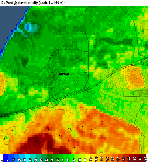
Below is the Elevation map of DuPont, which displays elevation range with different colors. Scale of the first map is from 1 to 166 m (3 to 545 ft) with average elevation of 87.1 meters (=286 ft) [note 1]
These maps also provides idea of topography and contour of this city, they are displayed at different zoom levels. More info about maps, scale and edge coordinates you can find below images.
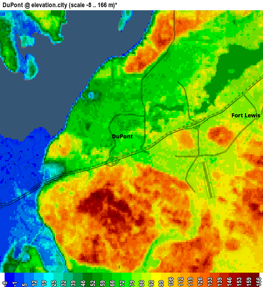
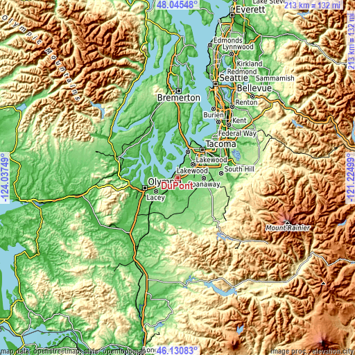
| \ | Map #1 | Map #2 | Topo.Map |
| Scale [m] | 1..166 m | -8..166 m | × |
| Scale [ft] | 3..545 ft | -26..545 ft | × |
| Average | 87.1 m = 286 ft | 83 m = 272 ft | × |
| Width | 6.65 km = 4.1 mi | 13.31 km = 8.3 mi | 212.9 km = 132.3 mi |
| Height | 6.65 km = 4.1 mi | 13.31 km = 8.3 mi | 212.9 km = 132.3 mi |
| ↑Max Latitude | 47.126668° | 47.156559° | 48.04548° |
| Latitude at center | 47.09676° | 47.09676° | 47.09676° |
| ↓Min Latitude | 47.066835° | 47.036894° | 46.13083° |
| ← Min Longitude | -122.675185° | -122.719131° | -124.03749° |
| Longitude center | -122.63124° | -122.63124° | -122.63124° |
| →Max Longitude | -122.587295° | -122.543349° | -121.22499° |
Nearby cities:
Cities around DuPont sort by population:
• Lakewood elevation 78 m
11.9 km,  45°
45°
• Lacey 62 m
16.1 km,  244°
244°
• Parkland 114 m
16.3 km,  66°
66°
• Spanaway 111 m
14.9 km,  86°
86°
• Joint Base Lewis McChord 82 m
4.3 km, 73°
• Steilacoom 22 m
8.4 km,  14°
14°
• Tanglewilde 62 m
12.5 km,  246°
246°
• Tanglewilde-Thompson Place 63 m
12.4 km, 245°
• Longbranch 7 m
15.7 km,  322°
322°
• North Yelm 91 m
15 km,  171°
171°
• North Fort Lewis 84 m
3.9 km, 45°
• McChord Air Force Base 92 m
11.3 km, 68°
Multilingual:
 En español:
DuPont elevación 73 m.
 En France:
DuPont élévation 73 m.


Sources and notes:
- [note 1] Map square and city borders are not equal. Map elevation data is calculated only from area inside that square.
- [src 1] Elevation data from geonames database provided with same terms of usage.
- [src 2] The elevation map of DuPont is generated using elevation data from NASA's 3 arcsec (90m) resolution SRTM data.
- [src 3] Base (background) map © OpenStreetMap contributors tiles are generated by Geofabrik and OpenTopoMap.
Copyright & License:
This DuPont Elevation Map is licensed under CC BY-SA. You may reuse any part from this page, if you give a proper credit by linking to this URL:
 More info on terms of use page.