Springfield elevation
Springfield (Oregon, Lane County), United States elevation is 139 meters and Springfield elevation in feet is 456 ft above sea level [src 1]. Springfield is a populated place (feature code) with elevation that is 140 meters (459 ft) smaller than average city elevation in United States.
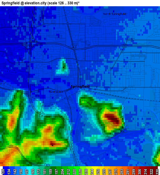
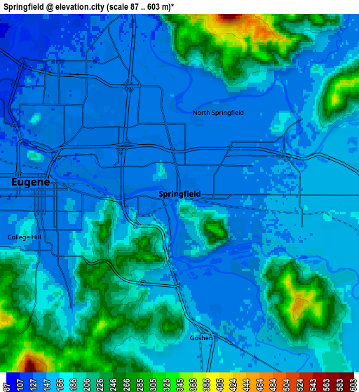
Below is the Elevation map of Springfield, which displays elevation range with different colors. Scale of the first map is from 126 to 330 m (413 to 1083 ft) with average elevation of 154.9 meters (=508 ft) [note 1]
These maps also provides idea of topography and contour of this city, they are displayed at different zoom levels. More info about maps, scale and edge coordinates you can find below images.
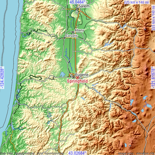
| \ | Map #1 | Map #2 | Topo.Map |
| Scale [m] | 126..330 m | 87..603 m | × |
| Scale [ft] | 413..1083 ft | 285..1978 ft | × |
| Average | 154.9 m = 508 ft | 176.2 m = 578 ft | × |
| Width | 7.02 km = 4.4 mi | 14.05 km = 8.7 mi | 224.8 km = 139.7 mi |
| Height | 7.02 km = 4.4 mi | 14.05 km = 8.7 mi | 224.8 km = 139.7 mi |
| ↑Max Latitude | 44.077819° | 44.10938° | 45.0484° |
| Latitude at center | 44.04624° | 44.04624° | 44.04624° |
| ↓Min Latitude | 44.014645° | 43.983032° | 43.02684° |
| ← Min Longitude | -123.065975° | -123.109921° | -124.42828° |
| Longitude center | -123.02203° | -123.02203° | -123.02203° |
| →Max Longitude | -122.978085° | -122.934139° | -121.61578° |
Nearby cities:
Cities around Springfield sort by population:
• Eugene elevation 132 m
5.2 km,  277°
277°
• Cottage Grove 197 m
27.8 km,  186°
186°
• Sweet Home 160 m
45.2 km,  30°
30°
• Junction City 101 m
24.2 km,  322°
322°
• Creswell 168 m
14.3 km,  180°
180°
• Veneta 129 m
26.3 km,  270°
270°
• Harrisburg 95 m
28 km,  334°
334°
• Culp Creek 294 m
40.6 km,  159°
159°
• Brownsville 112 m
38.7 km,  4°
4°
• Drain 91 m
49.2 km,  208°
208°
• Lowell 224 m
23.8 km,  126°
126°
• Coburg 123 m
10.7 km,  340°
340°
Multilingual:
 En español:
Springfield elevación 139 m.
 En France:
Springfield élévation 139 m.
 Auf Deutsch:
Springfield höhe über dem Meeresspiegel ist 139 m.

Sources and notes:
- [note 1] Map square and city borders are not equal. Map elevation data is calculated only from area inside that square.
- [src 1] Elevation data from geonames database provided with same terms of usage.
- [src 2] The elevation map of Springfield is generated using elevation data from NASA's 3 arcsec (90m) resolution SRTM data.
- [src 3] Base (background) map © OpenStreetMap contributors tiles are generated by Geofabrik and OpenTopoMap.
Copyright & License:
This Springfield Elevation Map is licensed under CC BY-SA. You may reuse any part from this page, if you give a proper credit by linking to this URL:
 More info on terms of use page.