Veneta elevation
Veneta (Oregon, Lane County), United States elevation is 129 meters and Veneta elevation in feet is 423 ft above sea level [src 1]. Veneta is a populated place (feature code) with elevation that is 150 meters (492 ft) smaller than average city elevation in United States.
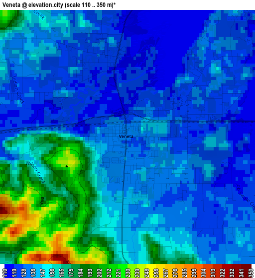
Below is the Elevation map of Veneta, which displays elevation range with different colors. Scale of the first map is from 110 to 350 m (361 to 1148 ft) with average elevation of 145.6 meters (=478 ft) [note 1]
These maps also provides idea of topography and contour of this city, they are displayed at different zoom levels. More info about maps, scale and edge coordinates you can find below images.
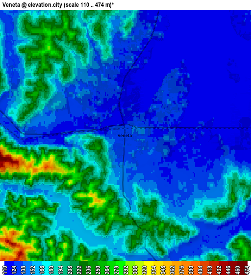
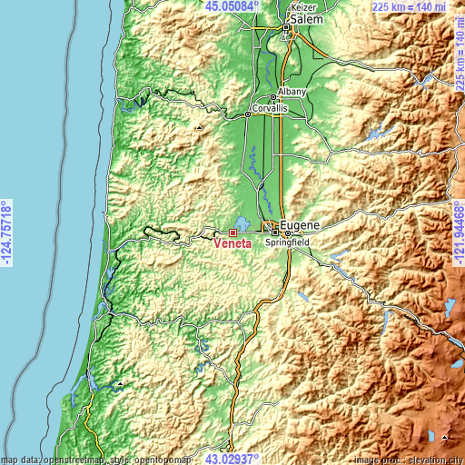
| \ | Map #1 | Map #2 | Topo.Map |
| Scale [m] | 110..350 m | 110..474 m | × |
| Scale [ft] | 361..1148 ft | 361..1555 ft | × |
| Average | 145.6 m = 478 ft | 165.8 m = 544 ft | × |
| Width | 7.02 km = 4.4 mi | 14.05 km = 8.7 mi | 224.8 km = 139.7 mi |
| Height | 7.02 km = 4.4 mi | 14.05 km = 8.7 mi | 224.8 km = 139.7 mi |
| ↑Max Latitude | 44.080307° | 44.111868° | 45.05084° |
| Latitude at center | 44.04873° | 44.04873° | 44.04873° |
| ↓Min Latitude | 44.017136° | 43.985525° | 43.02937° |
| ← Min Longitude | -123.394875° | -123.438821° | -124.75718° |
| Longitude center | -123.35093° | -123.35093° | -123.35093° |
| →Max Longitude | -123.306985° | -123.263039° | -121.94468° |
Nearby cities:
Cities around Veneta sort by population:
• Eugene elevation 132 m
21.1 km,  88°
88°
• Springfield 139 m
26.3 km, 90°
• Cottage Grove 197 m
36.4 km,  140°
140°
• Junction City 101 m
22.2 km,  31°
31°
• Creswell 168 m
29.9 km,  119°
119°
• Philomath 86 m
54.7 km,  358°
358°
• Harrisburg 95 m
28.9 km, 29°
• Brownsville 112 m
48.2 km,  37°
37°
• Drain 91 m
43.4 km,  176°
176°
• Lowell 224 m
47.6 km,  107°
107°
• Coburg 123 m
24.7 km,  66°
66°
• Yoncalla 114 m
50.4 km,  173°
173°
Multilingual:
 En español:
Veneta elevación 129 m.
 En France:
Veneta élévation 129 m.


Sources and notes:
- [note 1] Map square and city borders are not equal. Map elevation data is calculated only from area inside that square.
- [src 1] Elevation data from geonames database provided with same terms of usage.
- [src 2] The elevation map of Veneta is generated using elevation data from NASA's 3 arcsec (90m) resolution SRTM data.
- [src 3] Base (background) map © OpenStreetMap contributors tiles are generated by Geofabrik and OpenTopoMap.
Copyright & License:
This Veneta Elevation Map is licensed under CC BY-SA. You may reuse any part from this page, if you give a proper credit by linking to this URL:
 More info on terms of use page.