Culp Creek elevation
Culp Creek (Oregon, Lane County), United States elevation is 294 meters and Culp Creek elevation in feet is 965 ft above sea level [src 1]. Culp Creek is a populated place (feature code) with elevation that is 15 meters (49 ft) bigger than average city elevation in United States.
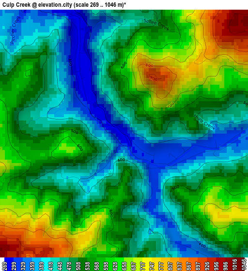
Below is the Elevation map of Culp Creek, which displays elevation range with different colors. Scale of the first map is from 269 to 1046 m (883 to 3432 ft) with average elevation of 532.9 meters (=1748 ft) [note 1]
These maps also provides idea of topography and contour of this city, they are displayed at different zoom levels. More info about maps, scale and edge coordinates you can find below images.
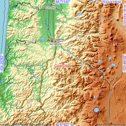
| \ | Map #1 | Topo.Map |
| Scale [m] | 269..1046 m | × |
| Scale [ft] | 883..3432 ft | × |
| Average | 532.9 m = 1748 ft | × |
| Width | 7.06 km = 4.4 mi | 226.1 km = 140.5 mi |
| Height | 7.06 km = 4.4 mi | 226.1 km = 140.5 mi |
| ↑Max Latitude | 43.735221° | 44.71145° |
| Latitude at center | 43.70346° | 43.70346° |
| ↓Min Latitude | 43.671682° | 42.67823° |
| ← Min Longitude | -122.891515° | -124.25382° |
| Longitude center | -122.84757° | -122.84757° |
| →Max Longitude | -122.803625° | -121.44132° |
Nearby cities:
Cities around Culp Creek sort by population:
• Eugene elevation 132 m
43.2 km,  333°
333°
• Springfield 139 m
40.6 km,  339°
339°
• Cottage Grove 197 m
20 km,  301°
301°
• Sutherlin 156 m
51.2 km,  227°
227°
• Creswell 168 m
27.8 km, 329°
• Veneta 129 m
55.7 km,  313°
313°
• Oakridge 368 m
31.4 km,  81°
81°
• Glide 214 m
49.2 km,  204°
204°
• Drain 91 m
38.2 km,  262°
262°
• Lowell 224 m
24.4 km,  12°
12°
• Coburg 123 m
51.3 km, 340°
• Yoncalla 114 m
37 km,  251°
251°
Multilingual:
 En español:
Culp Creek elevación 294 m.
 En France:
Culp Creek élévation 294 m.
 Auf Deutsch:
Culp Creek höhe über dem Meeresspiegel ist 294 m.

Sources and notes:
- [note 1] Map square and city borders are not equal. Map elevation data is calculated only from area inside that square.
- [src 1] Elevation data from geonames database provided with same terms of usage.
- [src 2] The elevation map of Culp Creek is generated using elevation data from NASA's 3 arcsec (90m) resolution SRTM data.
- [src 3] Base (background) map © OpenStreetMap contributors tiles are generated by Geofabrik and OpenTopoMap.
Copyright & License:
This Culp Creek Elevation Map is licensed under CC BY-SA. You may reuse any part from this page, if you give a proper credit by linking to this URL:
 More info on terms of use page.