Philipsburg elevation
Philipsburg (Montana, Granite County), United States elevation is 1602 meters and Philipsburg elevation in feet is 5256 ft above sea level [src 1]. Philipsburg is a seat of a second-order administrative division (feature code) with elevation that is 1323 meters (4341 ft) bigger than average city elevation in United States.
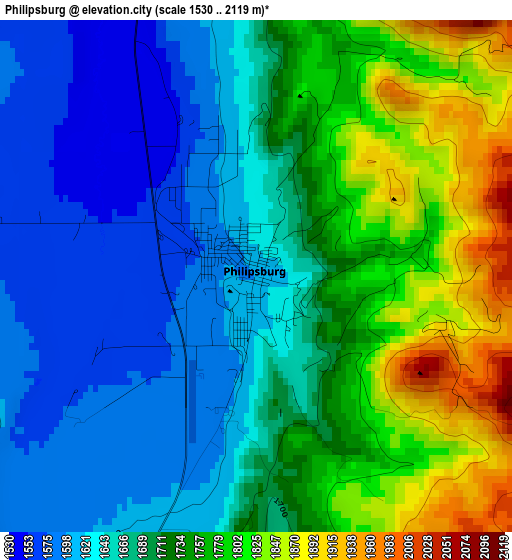
Below is the Elevation map of Philipsburg, which displays elevation range with different colors. Scale of the first map is from 1530 to 2119 m (5020 to 6952 ft) with average elevation of 1702.1 meters (=5584 ft) [note 1]
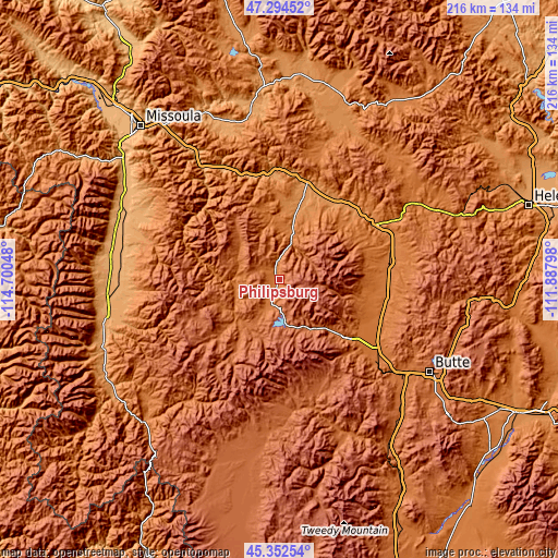
These maps also provides idea of topography and contour of this city, they are displayed at different zoom levels. More info about maps, scale and edge coordinates you can find below images.
| \ | Map #1 | Topo.Map |
| Scale [m] | 1530..2119 m | × |
| Scale [ft] | 5020..6952 ft | × |
| Average | 1702.1 m = 5584 ft | × |
| Width | 6.75 km = 4.2 mi | 215.9 km = 134.2 mi |
| Height | 6.75 km = 4.2 mi | 215.9 km = 134.2 mi |
| ↑Max Latitude | 46.362485° | 47.29452° |
| Latitude at center | 46.33215° | 46.33215° |
| ↓Min Latitude | 46.301798° | 45.35254° |
| ← Min Longitude | -113.338175° | -114.70048° |
| Longitude center | -113.29423° | -113.29423° |
| →Max Longitude | -113.250285° | -111.88798° |
Nearby cities:
Cities around Philipsburg sort by population:
• Missoula elevation 978 m
80.4 km,  318°
318°
• Butte 1690 m
68.9 km,  121°
121°
• Butte-Silver Bow (Balance) 1776 m
68.6 km,  134°
134°
• Anaconda 1599 m
35.3 km, 129°
• Hamilton 1089 m
67.2 km,  261°
261°
• Lolo 973 m
76.6 km,  308°
308°
• Warm Springs 1467 m
42.6 km,  113°
113°
• Deer Lodge 1393 m
43.9 km,  80°
80°
• East Missoula 997 m
77.8 km, 320°
• Stevensville 1012 m
64.3 km,  287°
287°
• Bonner-West Riverside 1003 m
75.6 km, 323°
• Clinton 1060 m
58.2 km,  326°
326°
Multilingual:
 En español:
Philipsburg elevación 1602 m.
 En France:
Philipsburg élévation 1602 m.
 Auf Deutsch:
Philipsburg höhe über dem Meeresspiegel ist 1602 m.

Sources and notes:
- [note 1] Map square and city borders are not equal. Map elevation data is calculated only from area inside that square.
- [src 1] Elevation data from geonames database provided with same terms of usage.
- [src 2] The elevation map of Philipsburg is generated using elevation data from NASA's 3 arcsec (90m) resolution SRTM data.
- [src 3] Base (background) map © OpenStreetMap contributors tiles are generated by Geofabrik and OpenTopoMap.
Copyright & License:
This Philipsburg Elevation Map is licensed under CC BY-SA. You may reuse any part from this page, if you give a proper credit by linking to this URL:
 More info on terms of use page.