Missoula elevation
Missoula (Montana, Missoula County), United States elevation is 978 meters and Missoula elevation in feet is 3209 ft above sea level [src 1]. Missoula is a seat of a second-order administrative division (feature code) with elevation that is 699 meters (2293 ft) bigger than average city elevation in United States.
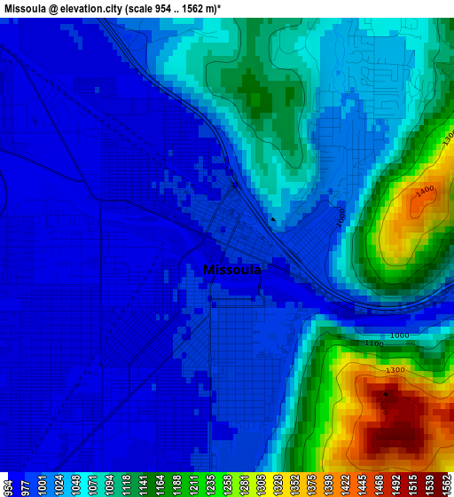
Below is the Elevation map of Missoula, which displays elevation range with different colors. Scale of the first map is from 954 to 1562 m (3130 to 5125 ft) with average elevation of 1050.8 meters (=3448 ft) [note 1]
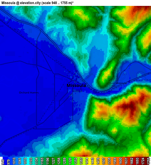
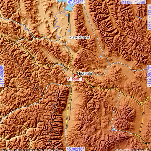
These maps also provides idea of topography and contour of this city, they are displayed at different zoom levels. More info about maps, scale and edge coordinates you can find below images.
| \ | Map #1 | Map #2 | Topo.Map |
| Scale [m] | 954..1562 m | 948..1755 m | × |
| Scale [ft] | 3130..5125 ft | 3110..5758 ft | × |
| Average | 1050.8 m = 3448 ft | 1117 m = 3665 ft | × |
| Width | 6.68 km = 4.2 mi | 13.36 km = 8.3 mi | 213.8 km = 132.8 mi |
| Height | 6.68 km = 4.2 mi | 13.36 km = 8.3 mi | 213.8 km = 132.8 mi |
| ↑Max Latitude | 46.902184° | 46.932201° | 47.8249° |
| Latitude at center | 46.87215° | 46.87215° | 46.87215° |
| ↓Min Latitude | 46.842099° | 46.812032° | 45.90218° |
| ← Min Longitude | -114.037945° | -114.081891° | -115.40025° |
| Longitude center | -113.994° | -113.994° | -113.994° |
| →Max Longitude | -113.950055° | -113.906109° | -112.58775° |
Nearby cities:
Cities around Missoula sort by population:
• Orchard Homes elevation 962 m
4.3 km,  256°
256°
• Hamilton 1089 m
70.7 km,  190°
190°
• Lolo 973 m
14.2 km,  207°
207°
• East Missoula 997 m
3.8 km,  92°
92°
• Ronan 931 m
73.5 km,  353°
353°
• Stevensville 1012 m
41 km, 190°
• Frenchtown 927 m
23.9 km,  311°
311°
• Bonner-West Riverside 1003 m
8.2 km, 86°
• Seeley Lake 1227 m
51.6 km,  48°
48°
• Clinton 1060 m
24.3 km,  118°
118°
• Philipsburg 1602 m
80.4 km,  138°
138°
• Superior 835 m
76.8 km,  297°
297°
Multilingual:
 En español:
Missoula elevación 978 m.
 En France:
Missoula élévation 978 m.
 Auf Deutsch:
Missoula höhe über dem Meeresspiegel ist 978 m.

Sources and notes:
- [note 1] Map square and city borders are not equal. Map elevation data is calculated only from area inside that square.
- [src 1] Elevation data from geonames database provided with same terms of usage.
- [src 2] The elevation map of Missoula is generated using elevation data from NASA's 3 arcsec (90m) resolution SRTM data.
- [src 3] Base (background) map © OpenStreetMap contributors tiles are generated by Geofabrik and OpenTopoMap.
Copyright & License:
This Missoula Elevation Map is licensed under CC BY-SA. You may reuse any part from this page, if you give a proper credit by linking to this URL:
 More info on terms of use page.