Butte elevation
Butte (Montana, Silver Bow County), United States elevation is 1690 meters and Butte elevation in feet is 5545 ft above sea level [src 1]. Butte is a seat of a second-order administrative division (feature code) with elevation that is 1411 meters (4629 ft) bigger than average city elevation in United States.
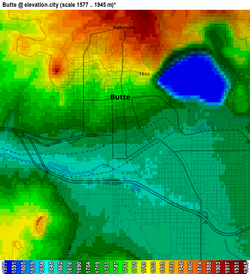
Below is the Elevation map of Butte, which displays elevation range with different colors. Scale of the first map is from 1577 to 1945 m (5174 to 6381 ft) with average elevation of 1720.2 meters (=5644 ft) [note 1]
These maps also provides idea of topography and contour of this city, they are displayed at different zoom levels. More info about maps, scale and edge coordinates you can find below images.
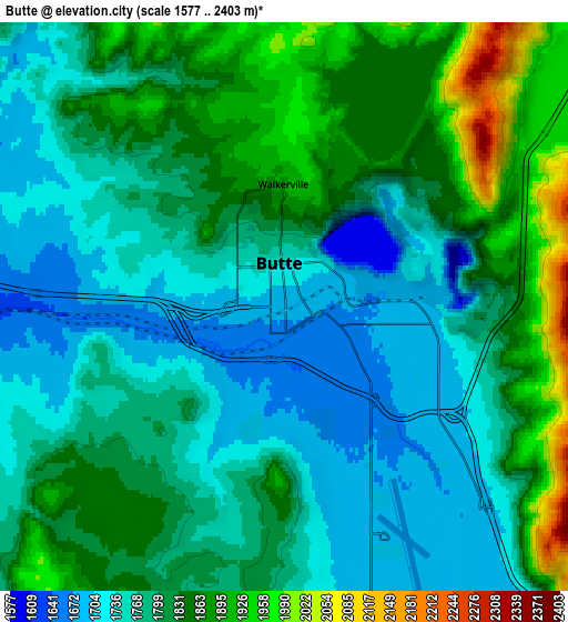
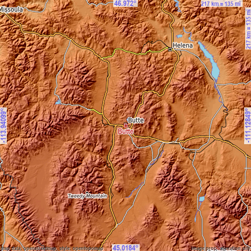
| \ | Map #1 | Map #2 | Topo.Map |
| Scale [m] | 1577..1945 m | 1577..2403 m | × |
| Scale [ft] | 5174..6381 ft | 5174..7884 ft | × |
| Average | 1720.2 m = 5644 ft | 1802.3 m = 5913 ft | × |
| Width | 6.79 km = 4.2 mi | 13.58 km = 8.4 mi | 217.2 km = 135 mi |
| Height | 6.79 km = 4.2 mi | 13.58 km = 8.4 mi | 217.2 km = 135 mi |
| ↑Max Latitude | 46.034336° | 46.064836° | 46.972° |
| Latitude at center | 46.00382° | 46.00382° | 46.00382° |
| ↓Min Latitude | 45.973287° | 45.942737° | 45.0184° |
| ← Min Longitude | -112.578685° | -112.622631° | -113.94099° |
| Longitude center | -112.53474° | -112.53474° | -112.53474° |
| →Max Longitude | -112.490795° | -112.446849° | -111.12849° |
Nearby cities:
Cities around Butte sort by population:
• Butte-Silver Bow (Balance) elevation 1776 m
14.8 km,  219°
219°
• Helena 1236 m
75.9 km,  30°
30°
• Anaconda 1599 m
34.4 km,  293°
293°
• Warm Springs 1467 m
27.6 km,  315°
315°
• Deer Lodge 1393 m
46.1 km,  340°
340°
• Montana City 1234 m
75.3 km,  37°
37°
• Three Forks 1243 m
77 km,  99°
99°
• Clancy 1294 m
66.4 km, 39°
• Helena West Side 1246 m
73.5 km, 26°
• Boulder 1496 m
41.1 km,  50°
50°
• Whitehall 1330 m
36.9 km,  113°
113°
• Philipsburg 1602 m
68.9 km,  301°
301°
Multilingual:
 En español:
Butte elevación 1690 m.
 En France:
Butte élévation 1690 m.


Sources and notes:
- [note 1] Map square and city borders are not equal. Map elevation data is calculated only from area inside that square.
- [src 1] Elevation data from geonames database provided with same terms of usage.
- [src 2] The elevation map of Butte is generated using elevation data from NASA's 3 arcsec (90m) resolution SRTM data.
- [src 3] Base (background) map © OpenStreetMap contributors tiles are generated by Geofabrik and OpenTopoMap.
Copyright & License:
This Butte Elevation Map is licensed under CC BY-SA. You may reuse any part from this page, if you give a proper credit by linking to this URL:
 More info on terms of use page.