Challis elevation
Challis (Idaho, Custer County), United States elevation is 1602 meters and Challis elevation in feet is 5256 ft above sea level [src 1]. Challis is a seat of a second-order administrative division (feature code) with elevation that is 1323 meters (4341 ft) bigger than average city elevation in United States.
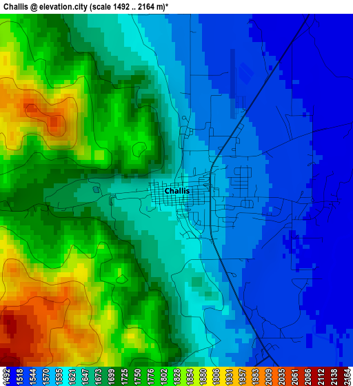
Below is the Elevation map of Challis, which displays elevation range with different colors. Scale of the first map is from 1492 to 2164 m (4895 to 7100 ft) with average elevation of 1663.7 meters (=5458 ft) [note 1]
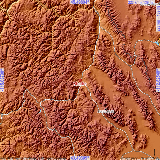
These maps also provides idea of topography and contour of this city, they are displayed at different zoom levels. More info about maps, scale and edge coordinates you can find below images.
| \ | Map #1 | Topo.Map |
| Scale [m] | 1492..2164 m | × |
| Scale [ft] | 4895..7100 ft | × |
| Average | 1663.7 m = 5458 ft | × |
| Width | 6.97 km = 4.3 mi | 223 km = 138.6 mi |
| Height | 6.97 km = 4.3 mi | 223 km = 138.6 mi |
| ↑Max Latitude | 44.535973° | 45.49894° |
| Latitude at center | 44.50464° | 44.50464° |
| ↓Min Latitude | 44.47329° | 43.49309° |
| ← Min Longitude | -114.275675° | -115.63798° |
| Longitude center | -114.23173° | -114.23173° |
| →Max Longitude | -114.187785° | -112.82548° |
Nearby cities:
Cities around Challis sort by population:
• Hailey elevation 1622 m
109.7 km,  183°
183°
• Dillon 1557 m
148.5 km,  57°
57°
• McCall 1531 m
154.3 km,  287°
287°
• Salmon 1202 m
79.2 km,  19°
19°
• Ketchum 1785 m
92.2 km,  186°
186°
• Bellevue 1579 m
115.8 km, 181°
• Sun Valley 1817 m
90.3 km, 186°
• Cascade 1449 m
143.5 km,  270°
270°
• Arco 1627 m
121.9 km,  142°
142°
• Dubois 1569 m
163.2 km,  102°
102°
• Idaho City 1190 m
148.3 km,  239°
239°
• Fairfield 1546 m
136.4 km,  199°
199°
Multilingual:
 En español:
Challis elevación 1602 m.
 En France:
Challis élévation 1602 m.
 Auf Deutsch:
Challis höhe über dem Meeresspiegel ist 1602 m.

Sources and notes:
- [note 1] Map square and city borders are not equal. Map elevation data is calculated only from area inside that square.
- [src 1] Elevation data from geonames database provided with same terms of usage.
- [src 2] The elevation map of Challis is generated using elevation data from NASA's 3 arcsec (90m) resolution SRTM data.
- [src 3] Base (background) map © OpenStreetMap contributors tiles are generated by Geofabrik and OpenTopoMap.
Copyright & License:
This Challis Elevation Map is licensed under CC BY-SA. You may reuse any part from this page, if you give a proper credit by linking to this URL:
 More info on terms of use page.