Arco elevation
Arco (Idaho, Butte County), United States elevation is 1627 meters and Arco elevation in feet is 5338 ft above sea level [src 1]. Arco is a seat of a second-order administrative division (feature code) with elevation that is 1348 meters (4423 ft) bigger than average city elevation in United States.
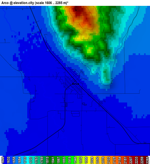
Below is the Elevation map of Arco, which displays elevation range with different colors. Scale of the first map is from 1606 to 2285 m (5269 to 7497 ft) with average elevation of 1677 meters (=5502 ft) [note 1]
These maps also provides idea of topography and contour of this city, they are displayed at different zoom levels. More info about maps, scale and edge coordinates you can find below images.
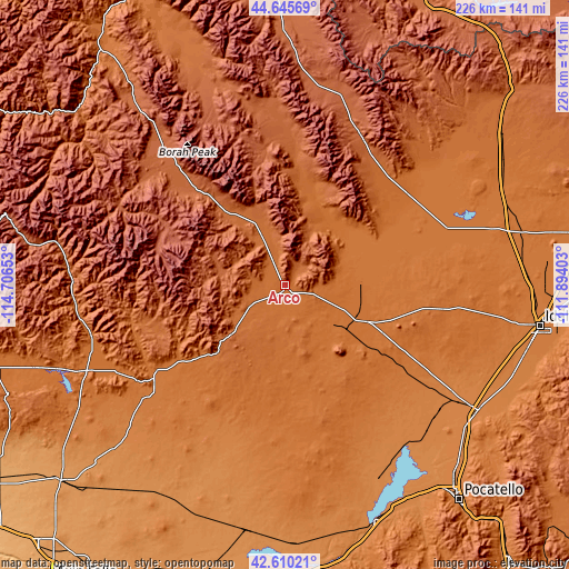
| \ | Map #1 | Topo.Map |
| Scale [m] | 1606..2285 m | × |
| Scale [ft] | 5269..7497 ft | × |
| Average | 1677 m = 5502 ft | × |
| Width | 7.07 km = 4.4 mi | 226.3 km = 140.6 mi |
| Height | 7.07 km = 4.4 mi | 226.3 km = 140.6 mi |
| ↑Max Latitude | 43.668366° | 44.64569° |
| Latitude at center | 43.63657° | 43.63657° |
| ↓Min Latitude | 43.604757° | 42.61021° |
| ← Min Longitude | -113.344225° | -114.70653° |
| Longitude center | -113.30028° | -113.30028° |
| →Max Longitude | -113.256335° | -111.89403° |
Nearby cities:
Cities around Arco sort by population:
• Idaho Falls elevation 1435 m
103.8 km,  100°
100°
• Blackfoot 1375 m
91.7 km,  122°
122°
• Hailey 1622 m
82.8 km,  260°
260°
• Shelley 1410 m
99.1 km,  106°
106°
• American Falls 1343 m
101.2 km,  159°
159°
• Fort Hall 1357 m
96.7 km,  133°
133°
• Ketchum 1785 m
85.7 km,  273°
273°
• Bellevue 1579 m
79.7 km, 256°
• Aberdeen 1341 m
85.6 km,  154°
154°
• Sun Valley 1817 m
84.8 km, 274°
• Moreland 1361 m
83.2 km, 123°
• Tyhee 1360 m
101.8 km,  138°
138°
Multilingual:
 En español:
Arco elevación 1627 m.
 En France:
Arco élévation 1627 m.


Sources and notes:
- [note 1] Map square and city borders are not equal. Map elevation data is calculated only from area inside that square.
- [src 1] Elevation data from geonames database provided with same terms of usage.
- [src 2] The elevation map of Arco is generated using elevation data from NASA's 3 arcsec (90m) resolution SRTM data.
- [src 3] Base (background) map © OpenStreetMap contributors tiles are generated by Geofabrik and OpenTopoMap.
Copyright & License:
This Arco Elevation Map is licensed under CC BY-SA. You may reuse any part from this page, if you give a proper credit by linking to this URL:
 More info on terms of use page.