Idaho Falls elevation
Idaho Falls (Idaho, Bonneville County), United States elevation is 1435 meters and Idaho Falls elevation in feet is 4708 ft above sea level [src 1]. Idaho Falls is a seat of a second-order administrative division (feature code) with elevation that is 1156 meters (3793 ft) bigger than average city elevation in United States.
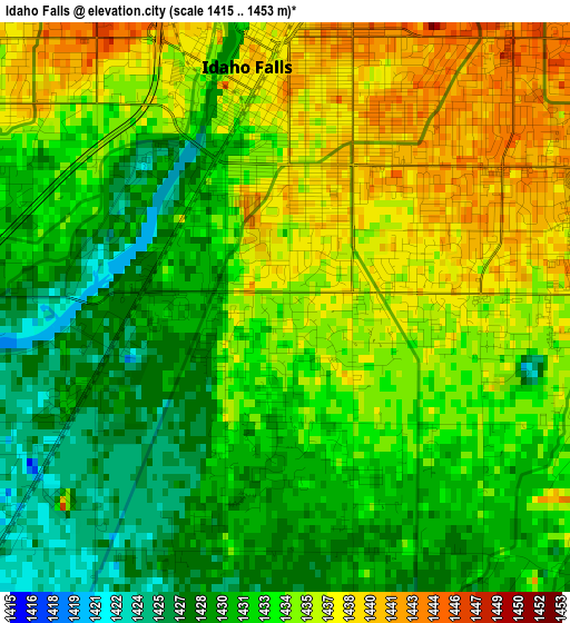
Below is the Elevation map of Idaho Falls, which displays elevation range with different colors. Scale of the first map is from 1415 to 1453 m (4642 to 4767 ft) with average elevation of 1433.1 meters (=4702 ft) [note 1]
These maps also provides idea of topography and contour of this city, they are displayed at different zoom levels. More info about maps, scale and edge coordinates you can find below images.
| \ | Map #1 | Map #2 | Topo.Map |
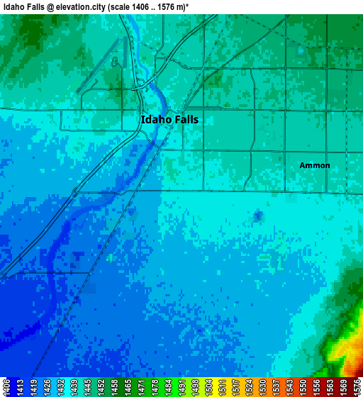
| Scale [m] | 1415..1453 m | 1406..1576 m | × |
| Scale [ft] | 4642..4767 ft | 4613..5171 ft | × |
| Average | 1433.1 m = 4702 ft | 1435.6 m = 4710 ft | × |
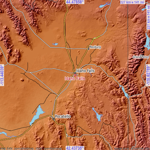
| Width | 7.09 km = 4.4 mi | 14.19 km = 8.8 mi | 227 km = 141.1 mi |
| Height | 7.09 km = 4.4 mi | 14.19 km = 8.8 mi | 227 km = 141.1 mi |
| ↑Max Latitude | 43.498466° | 43.530335° | 44.47858° |
| Latitude at center | 43.46658° | 43.46658° | 43.46658° |
| ↓Min Latitude | 43.434677° | 43.402757° | 42.43735° |
| ← Min Longitude | -112.078085° | -112.122031° | -113.44039° |
| Longitude center | -112.03414° | -112.03414° | -112.03414° |
| →Max Longitude | -111.990195° | -111.946249° | -110.62789° |
Nearby cities:
Cities around Idaho Falls sort by population:
• Rexburg elevation 1485 m
44.5 km,  26°
26°
• Ammon 1442 m
5.5 km,  86°
86°
• Blackfoot 1375 m
39.7 km,  219°
219°
• Shelley 1410 m
11.9 km, 217°
• Rigby 1481 m
24.8 km,  22°
22°
• Lincoln 1451 m
7.6 km,  47°
47°
• Saint Anthony 1519 m
62.3 km, 26°
• Fort Hall 1357 m
58.2 km,  214°
214°
• Iona 1460 m
10.5 km, 50°
• Sugar City 1494 m
50.7 km, 26°
• Moreland 1361 m
42.7 km,  230°
230°
• Ucon 1464 m
15.5 km, 21°
Multilingual:
 En español:
Idaho Falls elevación 1435 m.
 En France:
Idaho Falls élévation 1435 m.
 Auf Deutsch:
Idaho Falls höhe über dem Meeresspiegel ist 1435 m.

Sources and notes:
- [note 1] Map square and city borders are not equal. Map elevation data is calculated only from area inside that square.
- [src 1] Elevation data from geonames database provided with same terms of usage.
- [src 2] The elevation map of Idaho Falls is generated using elevation data from NASA's 3 arcsec (90m) resolution SRTM data.
- [src 3] Base (background) map © OpenStreetMap contributors tiles are generated by Geofabrik and OpenTopoMap.
Copyright & License:
This Idaho Falls Elevation Map is licensed under CC BY-SA. You may reuse any part from this page, if you give a proper credit by linking to this URL:
 More info on terms of use page.