Rangely elevation
Rangely (Colorado, Rio Blanco County), United States elevation is 1596 meters and Rangely elevation in feet is 5236 ft above sea level [src 1]. Rangely is a populated place (feature code) with elevation that is 1317 meters (4321 ft) bigger than average city elevation in United States.
Below is the Elevation map of Rangely, which displays elevation range with different colors. Scale of the first map is from 1579 to 1794 m (5180 to 5886 ft) with average elevation of 1634.3 meters (=5362 ft) [note 1]
These maps also provides idea of topography and contour of this city, they are displayed at different zoom levels. More info about maps, scale and edge coordinates you can find below images.
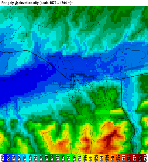
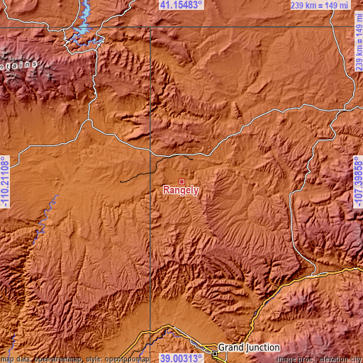
| \ | Map #1 | Topo.Map |
| Scale [m] | 1579..1794 m | × |
| Scale [ft] | 5180..5886 ft | × |
| Average | 1634.3 m = 5362 ft | × |
| Width | 7.48 km = 4.6 mi | 239.2 km = 148.6 mi |
| Height | 7.48 km = 4.6 mi | 239.2 km = 148.6 mi |
| ↑Max Latitude | 40.121093° | 41.15483° |
| Latitude at center | 40.08748° | 40.08748° |
| ↓Min Latitude | 40.053851° | 39.00313° |
| ← Min Longitude | -108.848775° | -110.21108° |
| Longitude center | -108.80483° | -108.80483° |
| →Max Longitude | -108.760885° | -107.39858° |
Nearby cities:
Cities around Rangely sort by population:
• Fruita elevation 1380 m
103.5 km,  176°
176°
• Vernal 1628 m
73.8 km,  303°
303°
• Rifle 1637 m
106.7 km,  125°
125°
• Redlands 1429 m
113.1 km,  172°
172°
• Roosevelt 1558 m
103.3 km,  283°
283°
• Battlement Mesa 1671 m
98 km,  137°
137°
• Maeser 1711 m
79.2 km, 303°
• Meeker 1907 m
76.1 km,  94°
94°
• Naples 1597 m
70 km, 302°
• Loma 1377 m
99.1 km, 180°
• Ballard 1544 m
99.3 km, 283°
• Parachute 1558 m
95.5 km, 137°
Multilingual:
 En español:
Rangely elevación 1596 m.
 En France:
Rangely élévation 1596 m.
 Auf Deutsch:
Rangely höhe über dem Meeresspiegel ist 1596 m.

Sources and notes:
- [note 1] Map square and city borders are not equal. Map elevation data is calculated only from area inside that square.
- [src 1] Elevation data from geonames database provided with same terms of usage.
- [src 2] The elevation map of Rangely is generated using elevation data from NASA's 3 arcsec (90m) resolution SRTM data.
- [src 3] Base (background) map © OpenStreetMap contributors tiles are generated by Geofabrik and OpenTopoMap.
Copyright & License:
This Rangely Elevation Map is licensed under CC BY-SA. You may reuse any part from this page, if you give a proper credit by linking to this URL:
 More info on terms of use page.