Rifle elevation
Rifle (Colorado, Garfield County), United States elevation is 1637 meters and Rifle elevation in feet is 5371 ft above sea level [src 1]. Rifle is a populated place (feature code) with elevation that is 1358 meters (4455 ft) bigger than average city elevation in United States.
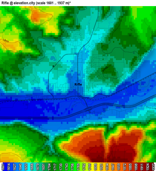
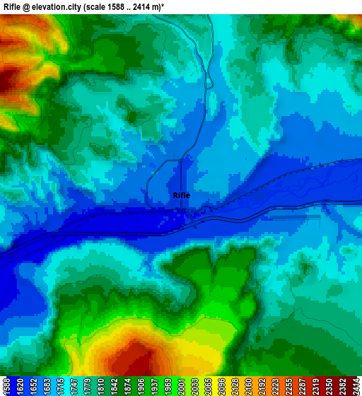
Below is the Elevation map of Rifle, which displays elevation range with different colors. Scale of the first map is from 1601 to 1937 m (5253 to 6355 ft) with average elevation of 1707.9 meters (=5603 ft) [note 1]
These maps also provides idea of topography and contour of this city, they are displayed at different zoom levels. More info about maps, scale and edge coordinates you can find below images.
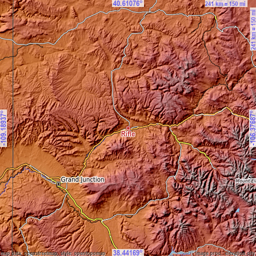
| \ | Map #1 | Map #2 | Topo.Map |
| Scale [m] | 1601..1937 m | 1588..2414 m | × |
| Scale [ft] | 5253..6355 ft | 5210..7920 ft | × |
| Average | 1707.9 m = 5603 ft | 1794.9 m = 5889 ft | × |
| Width | 7.54 km = 4.7 mi | 15.07 km = 9.4 mi | 241.2 km = 149.9 mi |
| Height | 7.54 km = 4.7 mi | 15.07 km = 9.4 mi | 241.2 km = 149.9 mi |
| ↑Max Latitude | 39.568584° | 39.602452° | 40.61076° |
| Latitude at center | 39.5347° | 39.5347° | 39.5347° |
| ↓Min Latitude | 39.500799° | 39.466882° | 38.44169° |
| ← Min Longitude | -107.827065° | -107.871011° | -109.18937° |
| Longitude center | -107.78312° | -107.78312° | -107.78312° |
| →Max Longitude | -107.739175° | -107.695229° | -106.37687° |
Nearby cities:
Cities around Rifle sort by population:
• Glenwood Springs elevation 1762 m
39.3 km,  87°
87°
• Gypsum 1929 m
72.3 km,  80°
80°
• Carbondale 1884 m
51.3 km,  106°
106°
• New Castle 1704 m
21.6 km, 78°
• Battlement Mesa 1671 m
23.2 km,  243°
243°
• Basalt 2023 m
67 km, 105°
• El Jebel 1982 m
61.5 km,  104°
104°
• Silt 1667 m
11 km, 81°
• Palisade 1446 m
67.9 km,  225°
225°
• Meeker 1907 m
57 km,  348°
348°
• Cedaredge 1905 m
71.5 km,  189°
189°
• Parachute 1558 m
24.9 km,  248°
248°
Multilingual:
 En español:
Rifle elevación 1637 m.
 En France:
Rifle élévation 1637 m.


Sources and notes:
- [note 1] Map square and city borders are not equal. Map elevation data is calculated only from area inside that square.
- [src 1] Elevation data from geonames database provided with same terms of usage.
- [src 2] The elevation map of Rifle is generated using elevation data from NASA's 3 arcsec (90m) resolution SRTM data.
- [src 3] Base (background) map © OpenStreetMap contributors tiles are generated by Geofabrik and OpenTopoMap.
Copyright & License:
This Rifle Elevation Map is licensed under CC BY-SA. You may reuse any part from this page, if you give a proper credit by linking to this URL:
 More info on terms of use page.