Ballard elevation
Ballard (Utah, Uintah County), United States elevation is 1544 meters and Ballard elevation in feet is 5066 ft above sea level [src 1]. Ballard is a populated place (feature code) with elevation that is 1265 meters (4150 ft) bigger than average city elevation in United States.
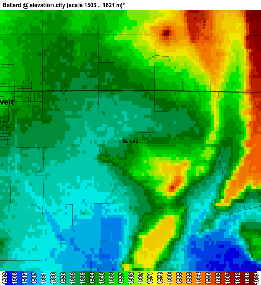
Below is the Elevation map of Ballard, which displays elevation range with different colors. Scale of the first map is from 1503 to 1621 m (4931 to 5318 ft) with average elevation of 1546 meters (=5072 ft) [note 1]
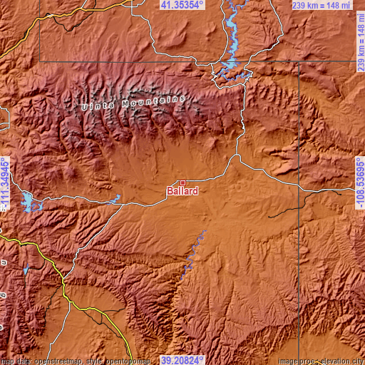
These maps also provides idea of topography and contour of this city, they are displayed at different zoom levels. More info about maps, scale and edge coordinates you can find below images.
| \ | Map #1 | Topo.Map |
| Scale [m] | 1503..1621 m | × |
| Scale [ft] | 4931..5318 ft | × |
| Average | 1546 m = 5072 ft | × |
| Width | 7.45 km = 4.6 mi | 238.5 km = 148.2 mi |
| Height | 7.45 km = 4.6 mi | 238.5 km = 148.2 mi |
| ↑Max Latitude | 40.322913° | 41.35354° |
| Latitude at center | 40.2894° | 40.2894° |
| ↓Min Latitude | 40.255871° | 39.20824° |
| ← Min Longitude | -109.987145° | -111.34945° |
| Longitude center | -109.9432° | -109.9432° |
| →Max Longitude | -109.899255° | -108.53695° |
Nearby cities:
Cities around Ballard sort by population:
• Vernal elevation 1628 m
39.7 km,  62°
62°
• Price 1699 m
106.6 km,  223°
223°
• Roosevelt 1558 m
4 km,  286°
286°
• Maeser 1711 m
36.7 km, 55°
• Rangely 1596 m
99.3 km,  103°
103°
• Naples 1597 m
40.6 km,  67°
67°
• Helper 1778 m
102.8 km,  229°
229°
• Duchesne 1684 m
41.5 km,  250°
250°
• Carbonville 1712 m
106.3 km, 225°
• East Carbon City 1926 m
91.8 km,  206°
206°
• Spring Glen 1762 m
104.5 km, 227°
• Manila 1938 m
79.9 km,  13°
13°
Multilingual:
 En español:
Ballard elevación 1544 m.
 En France:
Ballard élévation 1544 m.
 Auf Deutsch:
Ballard höhe über dem Meeresspiegel ist 1544 m.

Sources and notes:
- [note 1] Map square and city borders are not equal. Map elevation data is calculated only from area inside that square.
- [src 1] Elevation data from geonames database provided with same terms of usage.
- [src 2] The elevation map of Ballard is generated using elevation data from NASA's 3 arcsec (90m) resolution SRTM data.
- [src 3] Base (background) map © OpenStreetMap contributors tiles are generated by Geofabrik and OpenTopoMap.
Copyright & License:
This Ballard Elevation Map is licensed under CC BY-SA. You may reuse any part from this page, if you give a proper credit by linking to this URL:
 More info on terms of use page.