Akron elevation
Akron (Colorado, Washington County), United States elevation is 1421 meters and Akron elevation in feet is 4662 ft above sea level [src 1]. Akron is a seat of a second-order administrative division (feature code) with elevation that is 1142 meters (3747 ft) bigger than average city elevation in United States.
Below is the Elevation map of Akron, which displays elevation range with different colors. Scale of the first map is from 1386 to 1447 m (4547 to 4747 ft) with average elevation of 1418.6 meters (=4654 ft) [note 1]
These maps also provides idea of topography and contour of this city, they are displayed at different zoom levels. More info about maps, scale and edge coordinates you can find below images.
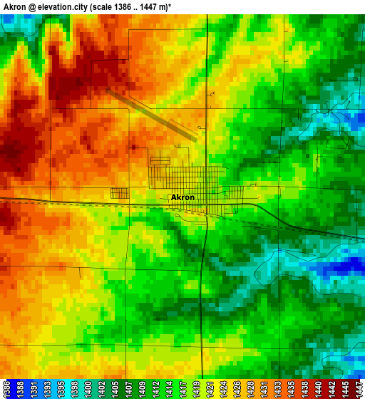
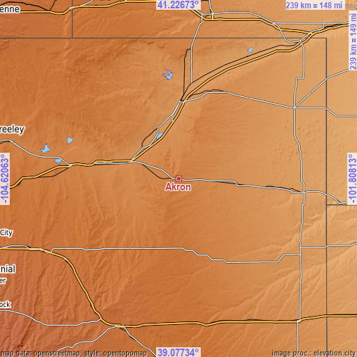
| \ | Map #1 | Topo.Map |
| Scale [m] | 1386..1447 m | × |
| Scale [ft] | 4547..4747 ft | × |
| Average | 1418.6 m = 4654 ft | × |
| Width | 7.47 km = 4.6 mi | 239 km = 148.5 mi |
| Height | 7.47 km = 4.6 mi | 239 km = 148.5 mi |
| ↑Max Latitude | 40.194116° | 41.22673° |
| Latitude at center | 40.16054° | 40.16054° |
| ↓Min Latitude | 40.126947° | 39.07734° |
| ← Min Longitude | -103.258325° | -104.62063° |
| Longitude center | -103.21438° | -103.21438° |
| →Max Longitude | -103.170435° | -101.80813° |
Nearby cities:
Cities around Akron sort by population:
• Sterling elevation 1201 m
51.7 km,  0°
0°
• Fort Morgan 1323 m
50.7 km,  281°
281°
• Sidney 1246 m
111 km,  10°
10°
• Brush 1294 m
36.4 km,  287°
287°
• Yuma 1262 m
41.8 km,  95°
95°
• Bennett 1675 m
112.6 km,  246°
246°
• Strasburg 1641 m
105.5 km,  243°
243°
• Wray 1090 m
84.8 km, 96°
• Holyoke 1139 m
90.5 km,  58°
58°
• Limon 1641 m
107.7 km,  202°
202°
• Keenesburg 1513 m
111.1 km,  267°
267°
• Byers 1588 m
99.8 km, 239°
Multilingual:
 En español:
Akron elevación 1421 m.
 En France:
Akron élévation 1421 m.


Sources and notes:
- [note 1] Map square and city borders are not equal. Map elevation data is calculated only from area inside that square.
- [src 1] Elevation data from geonames database provided with same terms of usage.
- [src 2] The elevation map of Akron is generated using elevation data from NASA's 3 arcsec (90m) resolution SRTM data.
- [src 3] Base (background) map © OpenStreetMap contributors tiles are generated by Geofabrik and OpenTopoMap.
Copyright & License:
This Akron Elevation Map is licensed under CC BY-SA. You may reuse any part from this page, if you give a proper credit by linking to this URL:
 More info on terms of use page.