Sterling elevation
Sterling (Colorado, Logan County), United States elevation is 1201 meters and Sterling elevation in feet is 3940 ft above sea level [src 1]. Sterling is a seat of a second-order administrative division (feature code) with elevation that is 922 meters (3025 ft) bigger than average city elevation in United States.
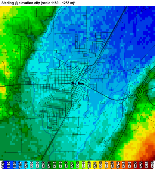
Below is the Elevation map of Sterling, which displays elevation range with different colors. Scale of the first map is from 1189 to 1258 m (3901 to 4127 ft) with average elevation of 1205.5 meters (=3955 ft) [note 1]
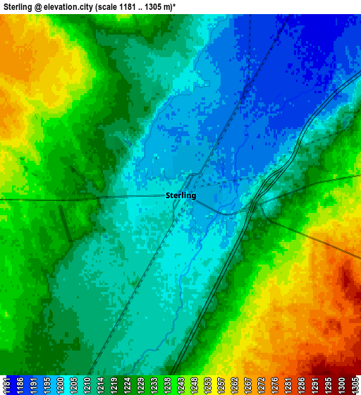
These maps also provides idea of topography and contour of this city, they are displayed at different zoom levels. More info about maps, scale and edge coordinates you can find below images.
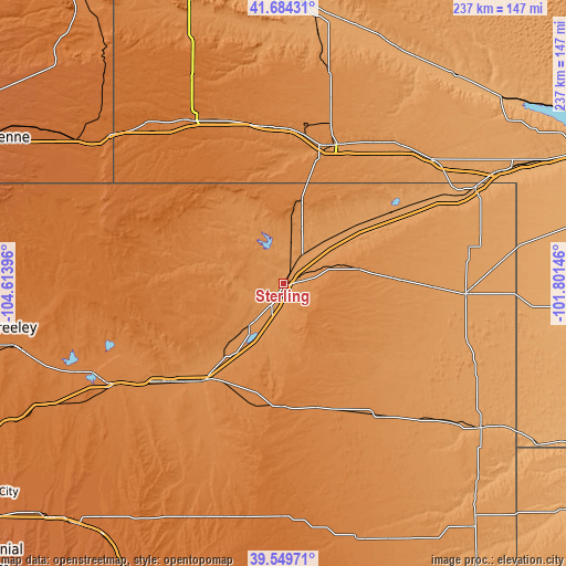
| \ | Map #1 | Map #2 | Topo.Map |
| Scale [m] | 1189..1258 m | 1181..1305 m | × |
| Scale [ft] | 3901..4127 ft | 3875..4281 ft | × |
| Average | 1205.5 m = 3955 ft | 1222.8 m = 4012 ft | × |
| Width | 7.42 km = 4.6 mi | 14.83 km = 9.2 mi | 237.3 km = 147.5 mi |
| Height | 7.42 km = 4.6 mi | 14.83 km = 9.2 mi | 237.3 km = 147.5 mi |
| ↑Max Latitude | 40.658885° | 40.692214° | 41.68431° |
| Latitude at center | 40.62554° | 40.62554° | 40.62554° |
| ↓Min Latitude | 40.592178° | 40.558799° | 39.54971° |
| ← Min Longitude | -103.251655° | -103.295601° | -104.61396° |
| Longitude center | -103.20771° | -103.20771° | -103.20771° |
| →Max Longitude | -103.163765° | -103.119819° | -101.80146° |
Nearby cities:
Cities around Sterling sort by population:
• Fort Morgan elevation 1323 m
65.2 km,  230°
230°
• Sidney 1246 m
60.7 km,  18°
18°
• Brush 1294 m
53.9 km,  220°
220°
• Yuma 1262 m
69.3 km,  143°
143°
• Kimball 1439 m
77.9 km,  330°
330°
• Wray 1090 m
103.4 km,  126°
126°
• Holyoke 1139 m
76.6 km,  93°
93°
• Akron 1421 m
51.7 km,  180°
180°
• Julesburg 1062 m
89.1 km,  63°
63°
• Pine Bluffs 1539 m
95.2 km,  310°
310°
• Chappell 1128 m
80.9 km,  50°
50°
• Harrisburg 1368 m
112.7 km,  336°
336°
Multilingual:
 En español:
Sterling elevación 1201 m.
 En France:
Sterling élévation 1201 m.
 Auf Deutsch:
Sterling höhe über dem Meeresspiegel ist 1201 m.

Sources and notes:
- [note 1] Map square and city borders are not equal. Map elevation data is calculated only from area inside that square.
- [src 1] Elevation data from geonames database provided with same terms of usage.
- [src 2] The elevation map of Sterling is generated using elevation data from NASA's 3 arcsec (90m) resolution SRTM data.
- [src 3] Base (background) map © OpenStreetMap contributors tiles are generated by Geofabrik and OpenTopoMap.
Copyright & License:
This Sterling Elevation Map is licensed under CC BY-SA. You may reuse any part from this page, if you give a proper credit by linking to this URL:
 More info on terms of use page.