Byers elevation
Byers (Colorado, Arapahoe County), United States elevation is 1588 meters and Byers elevation in feet is 5210 ft above sea level [src 1]. Byers is a populated place (feature code) with elevation that is 1309 meters (4295 ft) bigger than average city elevation in United States.
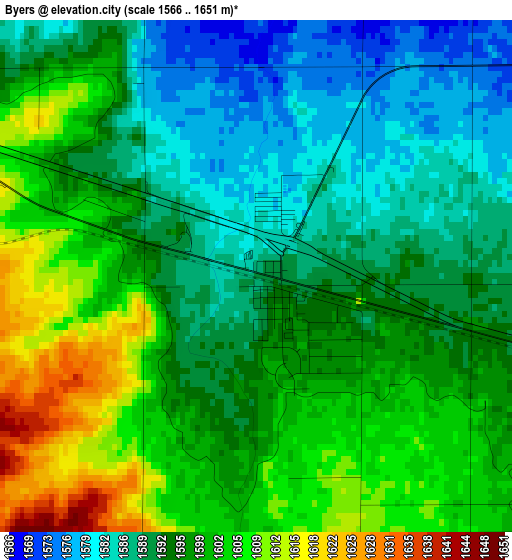
Below is the Elevation map of Byers, which displays elevation range with different colors. Scale of the first map is from 1566 to 1651 m (5138 to 5417 ft) with average elevation of 1595.7 meters (=5235 ft) [note 1]
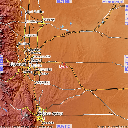
These maps also provides idea of topography and contour of this city, they are displayed at different zoom levels. More info about maps, scale and edge coordinates you can find below images.
| \ | Map #1 | Topo.Map |
| Scale [m] | 1566..1651 m | × |
| Scale [ft] | 5138..5417 ft | × |
| Average | 1595.7 m = 5235 ft | × |
| Width | 7.52 km = 4.7 mi | 240.6 km = 149.5 mi |
| Height | 7.52 km = 4.7 mi | 240.6 km = 149.5 mi |
| ↑Max Latitude | 39.745168° | 40.78466° |
| Latitude at center | 39.71137° | 39.71137° |
| ↓Min Latitude | 39.677556° | 38.62112° |
| ← Min Longitude | -104.271685° | -105.63399° |
| Longitude center | -104.22774° | -104.22774° |
| →Max Longitude | -104.183795° | -102.82149° |
Nearby cities:
Cities around Byers sort by population:
• Aurora elevation 1651 m
51.7 km,  272°
272°
• Parker 1795 m
50.5 km,  244°
244°
• The Pinery 1909 m
51.9 km, 236°
• Stonegate 1795 m
53.3 km,  247°
247°
• Lochbuie 1533 m
53.1 km,  308°
308°
• Dove Valley 1754 m
53.6 km, 253°
• Ponderosa Park 2037 m
49.5 km,  227°
227°
• Bennett 1675 m
17.9 km,  287°
287°
• Strasburg 1641 m
8.7 km, 290°
• Elizabeth 1981 m
50.3 km,  219°
219°
• Keenesburg 1513 m
50.7 km,  330°
330°
• Kiowa 1948 m
45.3 km,  206°
206°
Multilingual:
 En español:
Byers elevación 1588 m.
 En France:
Byers élévation 1588 m.


Sources and notes:
- [note 1] Map square and city borders are not equal. Map elevation data is calculated only from area inside that square.
- [src 1] Elevation data from geonames database provided with same terms of usage.
- [src 2] The elevation map of Byers is generated using elevation data from NASA's 3 arcsec (90m) resolution SRTM data.
- [src 3] Base (background) map © OpenStreetMap contributors tiles are generated by Geofabrik and OpenTopoMap.
Copyright & License:
This Byers Elevation Map is licensed under CC BY-SA. You may reuse any part from this page, if you give a proper credit by linking to this URL:
 More info on terms of use page.