Westwood elevation
Westwood (California, Lassen County), United States elevation is 1562 meters and Westwood elevation in feet is 5125 ft above sea level [src 1]. Westwood is a populated place (feature code) with elevation that is 1283 meters (4209 ft) bigger than average city elevation in United States.
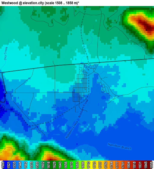
Below is the Elevation map of Westwood, which displays elevation range with different colors. Scale of the first map is from 1508 to 1858 m (4948 to 6096 ft) with average elevation of 1574.7 meters (=5166 ft) [note 1]
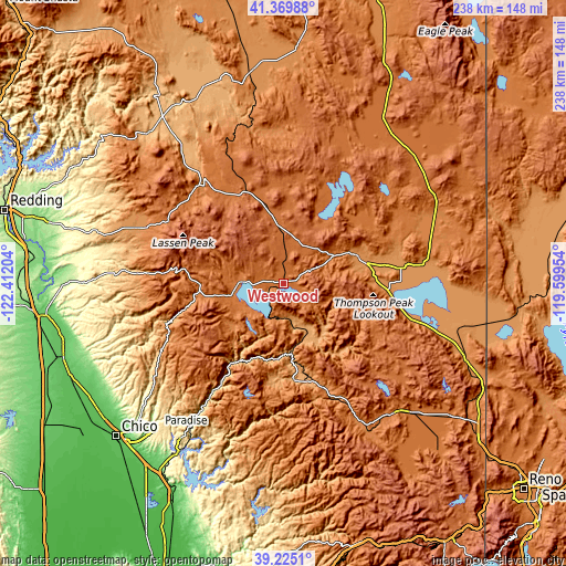
These maps also provides idea of topography and contour of this city, they are displayed at different zoom levels. More info about maps, scale and edge coordinates you can find below images.
| \ | Map #1 | Topo.Map |
| Scale [m] | 1508..1858 m | × |
| Scale [ft] | 4948..6096 ft | × |
| Average | 1574.7 m = 5166 ft | × |
| Width | 7.45 km = 4.6 mi | 238.5 km = 148.2 mi |
| Height | 7.45 km = 4.6 mi | 238.5 km = 148.2 mi |
| ↑Max Latitude | 40.339504° | 41.36988° |
| Latitude at center | 40.306° | 40.306° |
| ↓Min Latitude | 40.272479° | 39.2251° |
| ← Min Longitude | -121.049735° | -122.41204° |
| Longitude center | -121.00579° | -121.00579° |
| →Max Longitude | -120.961845° | -119.59954° |
Nearby cities:
Cities around Westwood sort by population:
• Paradise elevation 543 m
80.3 km,  220°
220°
• Susanville 1280 m
32.3 km,  67°
67°
• Magalia 707 m
73.4 km, 221°
• East Quincy 1065 m
42.4 km,  167°
167°
• Shingletown 1071 m
77.6 km,  285°
285°
• Chester 1381 m
19.2 km,  270°
270°
• Portola 1482 m
71.6 km,  140°
140°
• Quincy 1050 m
41.4 km, 172°
• Janesville 1293 m
40.9 km,  91°
91°
• Forest Ranch 741 m
73.8 km,  230°
230°
• Greenville 1093 m
19.1 km, 165°
• Johnstonville 1263 m
36.5 km,  76°
76°
Multilingual:
 En español:
Westwood elevación 1562 m.
 En France:
Westwood élévation 1562 m.
 Auf Deutsch:
Westwood höhe über dem Meeresspiegel ist 1562 m.

Sources and notes:
- [note 1] Map square and city borders are not equal. Map elevation data is calculated only from area inside that square.
- [src 1] Elevation data from geonames database provided with same terms of usage.
- [src 2] The elevation map of Westwood is generated using elevation data from NASA's 3 arcsec (90m) resolution SRTM data.
- [src 3] Base (background) map © OpenStreetMap contributors tiles are generated by Geofabrik and OpenTopoMap.
Copyright & License:
This Westwood Elevation Map is licensed under CC BY-SA. You may reuse any part from this page, if you give a proper credit by linking to this URL:
 More info on terms of use page.