Portola elevation
Portola (California, Plumas County), United States elevation is 1482 meters and Portola elevation in feet is 4862 ft above sea level [src 1]. Portola is a populated place (feature code) with elevation that is 1203 meters (3947 ft) bigger than average city elevation in United States.
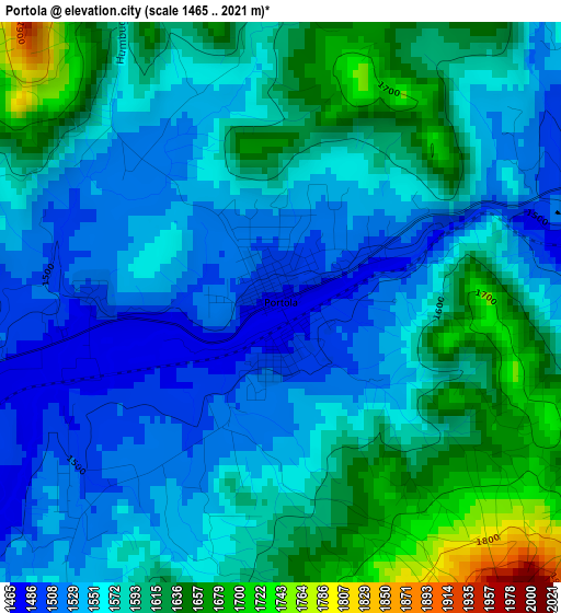
Below is the Elevation map of Portola, which displays elevation range with different colors. Scale of the first map is from 1465 to 2021 m (4806 to 6631 ft) with average elevation of 1577.5 meters (=5176 ft) [note 1]
These maps also provides idea of topography and contour of this city, they are displayed at different zoom levels. More info about maps, scale and edge coordinates you can find below images.
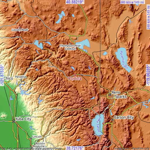
| \ | Map #1 | Topo.Map |
| Scale [m] | 1465..2021 m | × |
| Scale [ft] | 4806..6631 ft | × |
| Average | 1577.5 m = 5176 ft | × |
| Width | 7.51 km = 4.7 mi | 240.2 km = 149.3 mi |
| Height | 7.51 km = 4.7 mi | 240.2 km = 149.3 mi |
| ↑Max Latitude | 39.844209° | 40.88219° |
| Latitude at center | 39.81046° | 39.81046° |
| ↓Min Latitude | 39.776694° | 38.72176° |
| ← Min Longitude | -120.513045° | -121.87535° |
| Longitude center | -120.4691° | -120.4691° |
| →Max Longitude | -120.425155° | -119.06285° |
Nearby cities:
Cities around Portola sort by population:
• Sun Valley elevation 1440 m
63.9 km,  111°
111°
• Truckee 1774 m
59 km,  155°
155°
• Cold Springs 1543 m
44.5 km, 108°
• Lemmon Valley 1511 m
56.9 km, 109°
• East Quincy 1065 m
39.1 km,  290°
290°
• Quincy 1050 m
43.1 km, 289°
• Golden Valley 1554 m
59.1 km, 111°
• Verdi 1495 m
52.4 km,  128°
128°
• Janesville 1293 m
54.3 km,  355°
355°
• Mogul 1436 m
57 km, 125°
• Greenville 1093 m
55 km,  311°
311°
• Downieville 900 m
41.4 km,  227°
227°
Multilingual:
 En español:
Portola elevación 1482 m.
 En France:
Portola élévation 1482 m.
 Auf Deutsch:
Portola höhe über dem Meeresspiegel ist 1482 m.

Sources and notes:
- [note 1] Map square and city borders are not equal. Map elevation data is calculated only from area inside that square.
- [src 1] Elevation data from geonames database provided with same terms of usage.
- [src 2] The elevation map of Portola is generated using elevation data from NASA's 3 arcsec (90m) resolution SRTM data.
- [src 3] Base (background) map © OpenStreetMap contributors tiles are generated by Geofabrik and OpenTopoMap.
Copyright & License:
This Portola Elevation Map is licensed under CC BY-SA. You may reuse any part from this page, if you give a proper credit by linking to this URL:
 More info on terms of use page.