Downieville elevation
Downieville (California, Sierra County), United States elevation is 900 meters and Downieville elevation in feet is 2953 ft above sea level [src 1]. Downieville is a seat of a second-order administrative division (feature code) with elevation that is 621 meters (2037 ft) bigger than average city elevation in United States.
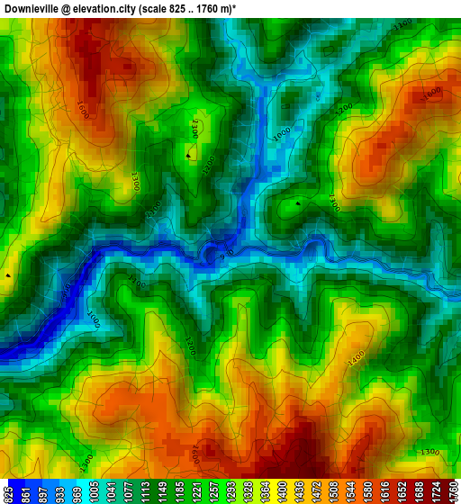
Below is the Elevation map of Downieville, which displays elevation range with different colors. Scale of the first map is from 825 to 1760 m (2707 to 5774 ft) with average elevation of 1261.8 meters (=4140 ft) [note 1]
These maps also provides idea of topography and contour of this city, they are displayed at different zoom levels. More info about maps, scale and edge coordinates you can find below images.
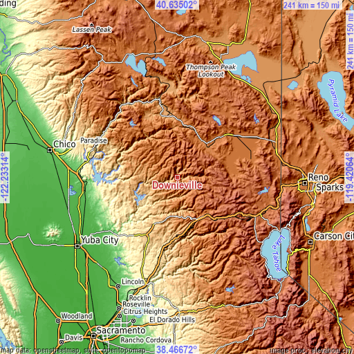
| \ | Map #1 | Topo.Map |
| Scale [m] | 825..1760 m | × |
| Scale [ft] | 2707..5774 ft | × |
| Average | 1261.8 m = 4140 ft | × |
| Width | 7.53 km = 4.7 mi | 241.1 km = 149.8 mi |
| Height | 7.53 km = 4.7 mi | 241.1 km = 149.8 mi |
| ↑Max Latitude | 39.593212° | 40.63502° |
| Latitude at center | 39.55934° | 39.55934° |
| ↓Min Latitude | 39.525451° | 38.46672° |
| ← Min Longitude | -120.870835° | -122.23314° |
| Longitude center | -120.82689° | -120.82689° |
| →Max Longitude | -120.782945° | -119.42064° |
Nearby cities:
Cities around Downieville sort by population:
• Grass Valley elevation 737 m
42.9 km,  208°
208°
• Oroville East 296 m
55.9 km,  264°
264°
• Alta Sierra 705 m
50.4 km,  202°
202°
• Lake Wildwood 461 m
48.5 km,  221°
221°
• Nevada City 758 m
36.9 km, 206°
• East Quincy 1065 m
42.1 km,  351°
351°
• Colfax 739 m
52.1 km,  192°
192°
• Portola 1482 m
41.4 km,  47°
47°
• Quincy 1050 m
43.2 km, 346°
• Penn Valley 432 m
51.1 km, 217°
• Berry Creek 641 m
50.3 km,  280°
280°
• Challenge-Brownsville 795 m
38.9 km,  254°
254°
Multilingual:
 En español:
Downieville elevación 900 m.
 En France:
Downieville élévation 900 m.
 Auf Deutsch:
Downieville höhe über dem Meeresspiegel ist 900 m.

Sources and notes:
- [note 1] Map square and city borders are not equal. Map elevation data is calculated only from area inside that square.
- [src 1] Elevation data from geonames database provided with same terms of usage.
- [src 2] The elevation map of Downieville is generated using elevation data from NASA's 3 arcsec (90m) resolution SRTM data.
- [src 3] Base (background) map © OpenStreetMap contributors tiles are generated by Geofabrik and OpenTopoMap.
Copyright & License:
This Downieville Elevation Map is licensed under CC BY-SA. You may reuse any part from this page, if you give a proper credit by linking to this URL:
 More info on terms of use page.