Penn Valley elevation
Penn Valley (California, Nevada County), United States elevation is 432 meters and Penn Valley elevation in feet is 1417 ft above sea level [src 1]. Penn Valley is a populated place (feature code) with elevation that is 153 meters (502 ft) bigger than average city elevation in United States.
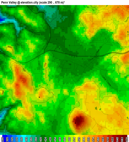
Below is the Elevation map of Penn Valley, which displays elevation range with different colors. Scale of the first map is from 290 to 678 m (951 to 2224 ft) with average elevation of 479 meters (=1572 ft) [note 1]
These maps also provides idea of topography and contour of this city, they are displayed at different zoom levels. More info about maps, scale and edge coordinates you can find below images.
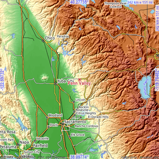
| \ | Map #1 | Topo.Map |
| Scale [m] | 290..678 m | × |
| Scale [ft] | 951..2224 ft | × |
| Average | 479 m = 1572 ft | × |
| Width | 7.57 km = 4.7 mi | 242.3 km = 150.6 mi |
| Height | 7.57 km = 4.7 mi | 242.3 km = 150.6 mi |
| ↑Max Latitude | 39.230049° | 40.27735° |
| Latitude at center | 39.196° | 39.196° |
| ↓Min Latitude | 39.161935° | 38.09774° |
| ← Min Longitude | -121.235015° | -122.59732° |
| Longitude center | -121.19107° | -121.19107° |
| →Max Longitude | -121.147125° | -119.78482° |
Nearby cities:
Cities around Penn Valley sort by population:
• Grass Valley elevation 737 m
11.5 km,  77°
77°
• Alta Sierra 705 m
13.3 km,  117°
117°
• Lake Wildwood 461 m
4.2 km,  348°
348°
• Lake of the Pines 464 m
20.9 km,  146°
146°
• Wheatland 26 m
28.8 km,  224°
224°
• Meadow Vista 530 m
26.1 km, 146°
• Nevada City 758 m
16.6 km,  63°
63°
• Loma Rica 123 m
23.4 km,  303°
303°
• Colfax 739 m
23.1 km, 117°
• Beale Air Force Base 57 m
17.1 km,  235°
235°
• Sheridan 34 m
28.8 km,  213°
213°
• Challenge-Brownsville 795 m
30.5 km, 348°
Multilingual:
 En español:
Penn Valley elevación 432 m.
 En France:
Penn Valley élévation 432 m.
 Auf Deutsch:
Penn Valley höhe über dem Meeresspiegel ist 432 m.

Sources and notes:
- [note 1] Map square and city borders are not equal. Map elevation data is calculated only from area inside that square.
- [src 1] Elevation data from geonames database provided with same terms of usage.
- [src 2] The elevation map of Penn Valley is generated using elevation data from NASA's 3 arcsec (90m) resolution SRTM data.
- [src 3] Base (background) map © OpenStreetMap contributors tiles are generated by Geofabrik and OpenTopoMap.
Copyright & License:
This Penn Valley Elevation Map is licensed under CC BY-SA. You may reuse any part from this page, if you give a proper credit by linking to this URL:
 More info on terms of use page.