Lake of the Pines elevation
Lake of the Pines (California, Nevada County), United States elevation is 464 meters and Lake of the Pines elevation in feet is 1522 ft above sea level [src 1]. Lake of the Pines is a populated place (feature code) with elevation that is 185 meters (607 ft) bigger than average city elevation in United States.
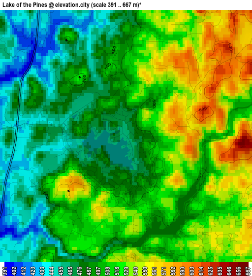
Below is the Elevation map of Lake of the Pines, which displays elevation range with different colors. Scale of the first map is from 391 to 667 m (1283 to 2188 ft) with average elevation of 504 meters (=1654 ft) [note 1]
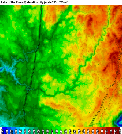
These maps also provides idea of topography and contour of this city, they are displayed at different zoom levels. More info about maps, scale and edge coordinates you can find below images.
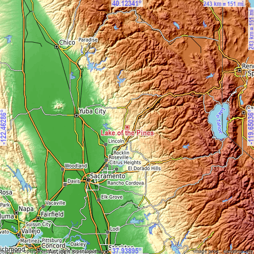
| \ | Map #1 | Map #2 | Topo.Map |
| Scale [m] | 391..667 m | 223..799 m | × |
| Scale [ft] | 1283..2188 ft | 732..2621 ft | × |
| Average | 504 m = 1654 ft | 525 m = 1722 ft | × |
| Width | 7.59 km = 4.7 mi | 15.18 km = 9.4 mi | 242.9 km = 150.9 mi |
| Height | 7.59 km = 4.7 mi | 15.18 km = 9.4 mi | 242.9 km = 150.9 mi |
| ↑Max Latitude | 39.073745° | 39.107853° | 40.12341° |
| Latitude at center | 39.03962° | 39.03962° | 39.03962° |
| ↓Min Latitude | 39.005479° | 38.971321° | 37.93895° |
| ← Min Longitude | -121.100555° | -121.144501° | -122.46286° |
| Longitude center | -121.05661° | -121.05661° | -121.05661° |
| →Max Longitude | -121.012665° | -120.968719° | -119.65036° |
Nearby cities:
Cities around Lake of the Pines sort by population:
• Auburn elevation 378 m
16 km,  186°
186°
• North Auburn 452 m
12.2 km, 190°
• Grass Valley 737 m
20 km,  358°
358°
• Alta Sierra 705 m
11.3 km,  1°
1°
• Cool 468 m
17.3 km,  167°
167°
• Auburn Lake Trails 585 m
16.6 km,  147°
147°
• Meadow Vista 530 m
5.2 km, 145°
• Georgetown 811 m
23.9 km,  128°
128°
• Colfax 739 m
11.2 km,  52°
52°
• Penn Valley 432 m
20.9 km,  326°
326°
• Foresthill 985 m
20.7 km,  95°
95°
• Newcastle 290 m
19.6 km,  199°
199°
Multilingual:
 En español:
Lake of the Pines elevación 464 m.
 En France:
Lake of the Pines élévation 464 m.
 Auf Deutsch:
Lake of the Pines höhe über dem Meeresspiegel ist 464 m.

Sources and notes:
- [note 1] Map square and city borders are not equal. Map elevation data is calculated only from area inside that square.
- [src 1] Elevation data from geonames database provided with same terms of usage.
- [src 2] The elevation map of Lake of the Pines is generated using elevation data from NASA's 3 arcsec (90m) resolution SRTM data.
- [src 3] Base (background) map © OpenStreetMap contributors tiles are generated by Geofabrik and OpenTopoMap.
Copyright & License:
This Lake of the Pines Elevation Map is licensed under CC BY-SA. You may reuse any part from this page, if you give a proper credit by linking to this URL:
 More info on terms of use page.