Auburn elevation
Auburn (California, Placer County), United States elevation is 378 meters and Auburn elevation in feet is 1240 ft above sea level [src 1]. Auburn is a seat of a second-order administrative division (feature code) with elevation that is 99 meters (325 ft) bigger than average city elevation in United States.
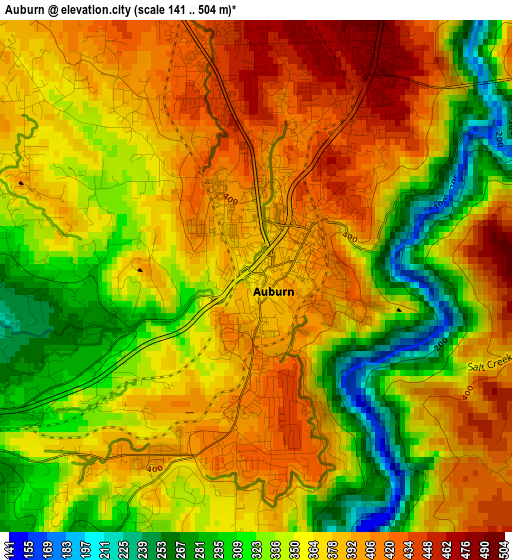
Below is the Elevation map of Auburn, which displays elevation range with different colors. Scale of the first map is from 141 to 504 m (463 to 1654 ft) with average elevation of 362.6 meters (=1190 ft) [note 1]
These maps also provides idea of topography and contour of this city, they are displayed at different zoom levels. More info about maps, scale and edge coordinates you can find below images.
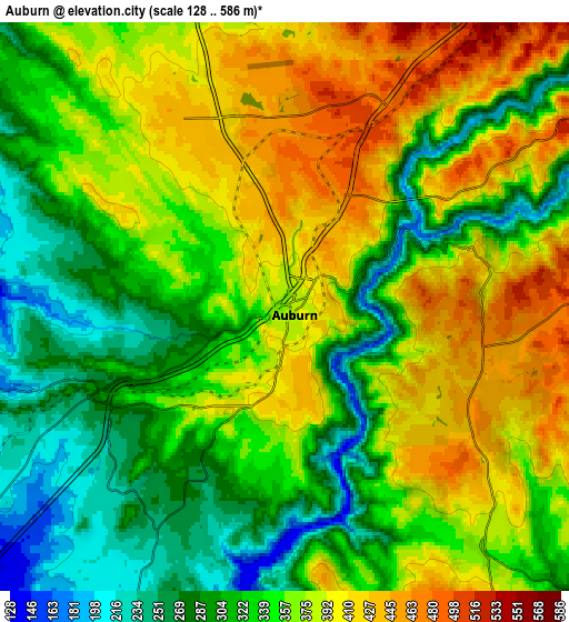
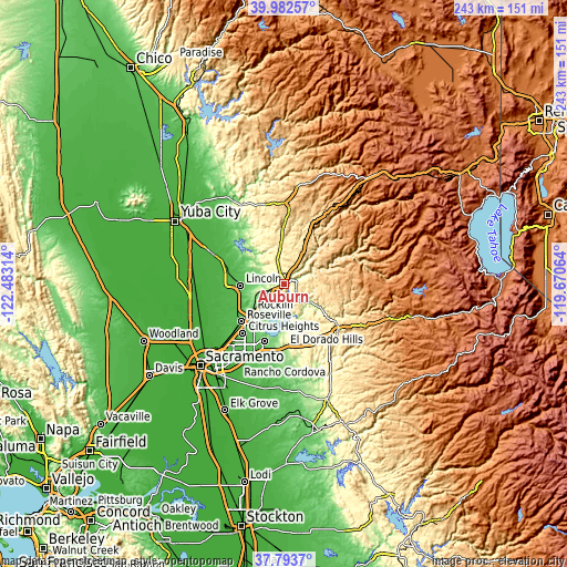
| \ | Map #1 | Map #2 | Topo.Map |
| Scale [m] | 141..504 m | 128..586 m | × |
| Scale [ft] | 463..1654 ft | 420..1923 ft | × |
| Average | 362.6 m = 1190 ft | 352 m = 1155 ft | × |
| Width | 7.61 km = 4.7 mi | 15.21 km = 9.5 mi | 243.4 km = 151.2 mi |
| Height | 7.61 km = 4.7 mi | 15.21 km = 9.5 mi | 243.4 km = 151.2 mi |
| ↑Max Latitude | 38.930764° | 38.964941° | 39.98257° |
| Latitude at center | 38.89657° | 38.89657° | 38.89657° |
| ↓Min Latitude | 38.86236° | 38.828133° | 37.7937° |
| ← Min Longitude | -121.120835° | -121.164781° | -122.48314° |
| Longitude center | -121.07689° | -121.07689° | -121.07689° |
| →Max Longitude | -121.032945° | -120.988999° | -119.67064° |
Nearby cities:
Cities around Auburn sort by population:
• Rocklin elevation 76 m
18.1 km,  229°
229°
• Lincoln 51 m
18.7 km,  268°
268°
• El Dorado Hills 238 m
23.4 km,  181°
181°
• Granite Bay 132 m
16.6 km,  206°
206°
• North Auburn 452 m
3.9 km,  353°
353°
• Loomis 121 m
13.1 km, 230°
• Cool 468 m
5.5 km,  100°
100°
• Lake of the Pines 464 m
16 km,  6°
6°
• Auburn Lake Trails 585 m
10.9 km,  79°
79°
• Meadow Vista 530 m
12.5 km,  22°
22°
• Georgetown 811 m
20.7 km,  86°
86°
• Newcastle 290 m
5.5 km,  242°
242°
Multilingual:
 En español:
Auburn elevación 378 m.
 En France:
Auburn élévation 378 m.


Sources and notes:
- [note 1] Map square and city borders are not equal. Map elevation data is calculated only from area inside that square.
- [src 1] Elevation data from geonames database provided with same terms of usage.
- [src 2] The elevation map of Auburn is generated using elevation data from NASA's 3 arcsec (90m) resolution SRTM data.
- [src 3] Base (background) map © OpenStreetMap contributors tiles are generated by Geofabrik and OpenTopoMap.
Copyright & License:
This Auburn Elevation Map is licensed under CC BY-SA. You may reuse any part from this page, if you give a proper credit by linking to this URL:
 More info on terms of use page.