Loomis elevation
Loomis (California, Placer County), United States elevation is 121 meters and Loomis elevation in feet is 397 ft above sea level [src 1]. Loomis is a populated place (feature code) with elevation that is 158 meters (518 ft) smaller than average city elevation in United States.
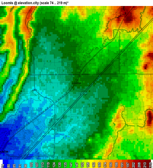
Below is the Elevation map of Loomis, which displays elevation range with different colors. Scale of the first map is from 74 to 219 m (243 to 719 ft) with average elevation of 130.1 meters (=427 ft) [note 1]
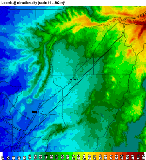
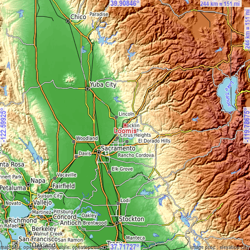
These maps also provides idea of topography and contour of this city, they are displayed at different zoom levels. More info about maps, scale and edge coordinates you can find below images.
| \ | Map #1 | Map #2 | Topo.Map |
| Scale [m] | 74..219 m | 41..392 m | × |
| Scale [ft] | 243..719 ft | 135..1286 ft | × |
| Average | 130.1 m = 427 ft | 141.2 m = 463 ft | × |
| Width | 7.61 km = 4.7 mi | 15.23 km = 9.5 mi | 243.6 km = 151.4 mi |
| Height | 7.61 km = 4.7 mi | 15.23 km = 9.5 mi | 243.6 km = 151.4 mi |
| ↑Max Latitude | 38.85552° | 38.889733° | 39.90846° |
| Latitude at center | 38.82129° | 38.82129° | 38.82129° |
| ↓Min Latitude | 38.787044° | 38.752781° | 37.71727° |
| ← Min Longitude | -121.236945° | -121.280891° | -122.59925° |
| Longitude center | -121.193° | -121.193° | -121.193° |
| →Max Longitude | -121.149055° | -121.105109° | -119.78675° |
Nearby cities:
Cities around Loomis sort by population:
• Roseville elevation 51 m
11.3 km,  226°
226°
• Citrus Heights 52 m
14.8 km,  211°
211°
• Folsom 66 m
16 km,  174°
174°
• Rocklin 76 m
5 km, 227°
• Lincoln 51 m
11.7 km,  312°
312°
• Antelope 49 m
17.3 km,  223°
223°
• Orangevale 74 m
16.1 km,  190°
190°
• Granite Bay 132 m
6.9 km,  158°
158°
• Auburn 378 m
13.1 km,  50°
50°
• North Auburn 452 m
15.6 km,  38°
38°
• Cool 468 m
17.1 km,  64°
64°
• Newcastle 290 m
7.8 km, 41°
Multilingual:
 En español:
Loomis elevación 121 m.
 En France:
Loomis élévation 121 m.


Sources and notes:
- [note 1] Map square and city borders are not equal. Map elevation data is calculated only from area inside that square.
- [src 1] Elevation data from geonames database provided with same terms of usage.
- [src 2] The elevation map of Loomis is generated using elevation data from NASA's 3 arcsec (90m) resolution SRTM data.
- [src 3] Base (background) map © OpenStreetMap contributors tiles are generated by Geofabrik and OpenTopoMap.
Copyright & License:
This Loomis Elevation Map is licensed under CC BY-SA. You may reuse any part from this page, if you give a proper credit by linking to this URL:
 More info on terms of use page.