Verdi elevation
Verdi (Nevada, Washoe County), United States elevation is 1495 meters and Verdi elevation in feet is 4905 ft above sea level [src 1]. Verdi is a populated place (feature code) with elevation that is 1216 meters (3990 ft) bigger than average city elevation in United States.
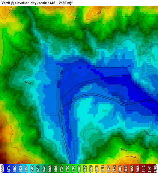
Below is the Elevation map of Verdi, which displays elevation range with different colors. Scale of the first map is from 1446 to 2169 m (4744 to 7116 ft) with average elevation of 1648.4 meters (=5408 ft) [note 1]
These maps also provides idea of topography and contour of this city, they are displayed at different zoom levels. More info about maps, scale and edge coordinates you can find below images.
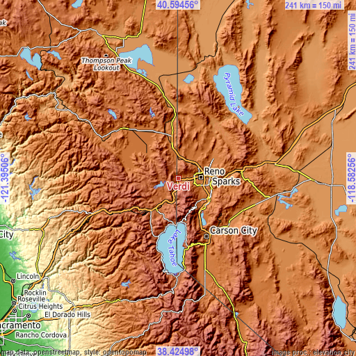
| \ | Map #1 | Topo.Map |
| Scale [m] | 1446..2169 m | × |
| Scale [ft] | 4744..7116 ft | × |
| Average | 1648.4 m = 5408 ft | × |
| Width | 7.54 km = 4.7 mi | 241.2 km = 149.9 mi |
| Height | 7.54 km = 4.7 mi | 241.2 km = 149.9 mi |
| ↑Max Latitude | 39.552132° | 40.59456° |
| Latitude at center | 39.51824° | 39.51824° |
| ↓Min Latitude | 39.484331° | 38.42498° |
| ← Min Longitude | -120.032755° | -121.39506° |
| Longitude center | -119.98881° | -119.98881° |
| →Max Longitude | -119.944865° | -118.58256° |
Nearby cities:
Cities around Verdi sort by population:
• Reno elevation 1380 m
15.1 km,  85°
85°
• Sparks 1348 m
20.3 km,  84°
84°
• Sun Valley 1440 m
20.2 km,  64°
64°
• Truckee 1774 m
27 km,  218°
218°
• Spanish Springs 1378 m
28.2 km, 58°
• Incline Village 1966 m
29.7 km,  177°
177°
• Cold Springs 1543 m
18 km,  3°
3°
• Lemmon Valley 1511 m
18.1 km,  43°
43°
• Kings Beach 1909 m
31.4 km,  185°
185°
• Golden Valley 1554 m
17.6 km,  52°
52°
• Tahoe Vista 1910 m
31.4 km, 189°
• Mogul 1436 m
5.4 km,  95°
95°
Multilingual:
 En español:
Verdi elevación 1495 m.
 En France:
Verdi élévation 1495 m.


Sources and notes:
- [note 1] Map square and city borders are not equal. Map elevation data is calculated only from area inside that square.
- [src 1] Elevation data from geonames database provided with same terms of usage.
- [src 2] The elevation map of Verdi is generated using elevation data from NASA's 3 arcsec (90m) resolution SRTM data.
- [src 3] Base (background) map © OpenStreetMap contributors tiles are generated by Geofabrik and OpenTopoMap.
Copyright & License:
This Verdi Elevation Map is licensed under CC BY-SA. You may reuse any part from this page, if you give a proper credit by linking to this URL:
 More info on terms of use page.