Magalia elevation
Magalia (California, Butte County), United States elevation is 707 meters and Magalia elevation in feet is 2320 ft above sea level [src 1]. Magalia is a populated place (feature code) with elevation that is 428 meters (1404 ft) bigger than average city elevation in United States.
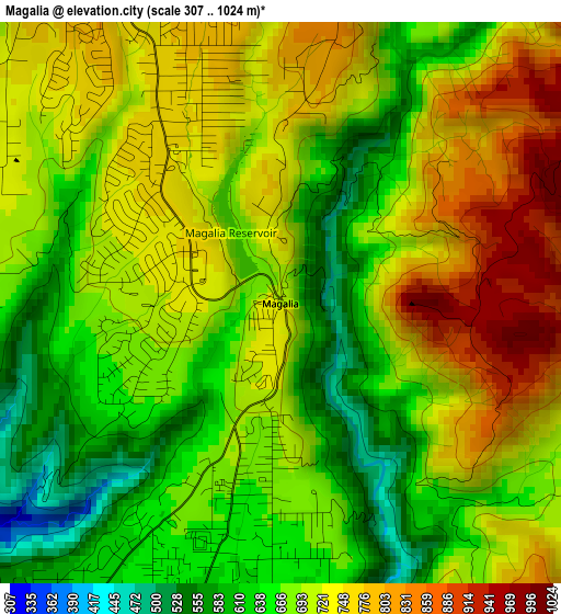
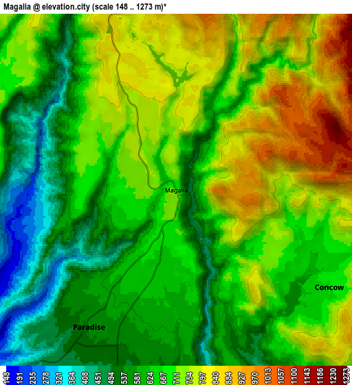
Below is the Elevation map of Magalia, which displays elevation range with different colors. Scale of the first map is from 307 to 1024 m (1007 to 3360 ft) with average elevation of 701 meters (=2300 ft) [note 1]
These maps also provides idea of topography and contour of this city, they are displayed at different zoom levels. More info about maps, scale and edge coordinates you can find below images.
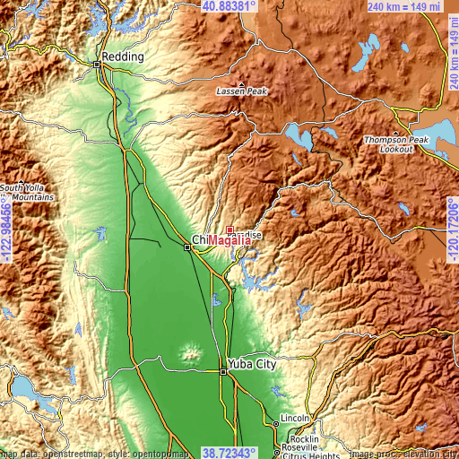
| \ | Map #1 | Map #2 | Topo.Map |
| Scale [m] | 307..1024 m | 148..1273 m | × |
| Scale [ft] | 1007..3360 ft | 486..4177 ft | × |
| Average | 701 m = 2300 ft | 678.8 m = 2227 ft | × |
| Width | 7.51 km = 4.7 mi | 15.01 km = 9.3 mi | 240.2 km = 149.3 mi |
| Height | 7.51 km = 4.7 mi | 15.01 km = 9.3 mi | 240.2 km = 149.3 mi |
| ↑Max Latitude | 39.845858° | 39.87959° | 40.88381° |
| Latitude at center | 39.81211° | 39.81211° | 39.81211° |
| ↓Min Latitude | 39.778345° | 39.744564° | 38.72343° |
| ← Min Longitude | -121.622255° | -121.666201° | -122.98456° |
| Longitude center | -121.57831° | -121.57831° | -121.57831° |
| →Max Longitude | -121.534365° | -121.490419° | -120.17206° |
Nearby cities:
Cities around Magalia sort by population:
• Chico elevation 64 m
24 km,  247°
247°
• Paradise 543 m
6.9 km,  212°
212°
• Oroville 49 m
33.2 km,  176°
176°
• Oroville East 296 m
34.6 km,  165°
165°
• Thermalito 67 m
33.5 km, 181°
• South Oroville 58 m
35.2 km, 176°
• Durham 47 m
26.4 km,  225°
225°
• Palermo 59 m
42 km, 175°
• Hamilton City 48 m
38 km,  258°
258°
• Biggs 28 m
45.9 km,  194°
194°
• Berry Creek 641 m
23.8 km,  141°
141°
• Forest Ranch 741 m
11.2 km,  313°
313°
Multilingual:
 En español:
Magalia elevación 707 m.
 En France:
Magalia élévation 707 m.


Sources and notes:
- [note 1] Map square and city borders are not equal. Map elevation data is calculated only from area inside that square.
- [src 1] Elevation data from geonames database provided with same terms of usage.
- [src 2] The elevation map of Magalia is generated using elevation data from NASA's 3 arcsec (90m) resolution SRTM data.
- [src 3] Base (background) map © OpenStreetMap contributors tiles are generated by Geofabrik and OpenTopoMap.
Copyright & License:
This Magalia Elevation Map is licensed under CC BY-SA. You may reuse any part from this page, if you give a proper credit by linking to this URL:
 More info on terms of use page.