Oroville elevation
Oroville (California, Butte County), United States elevation is 49 meters and Oroville elevation in feet is 161 ft above sea level [src 1]. Oroville is a seat of a second-order administrative division (feature code) with elevation that is 230 meters (755 ft) smaller than average city elevation in United States.
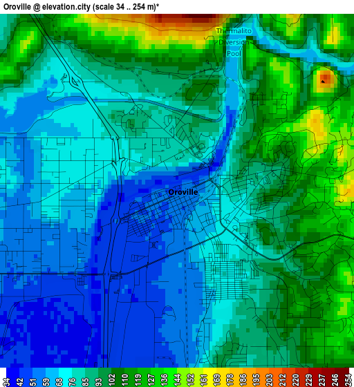
Below is the Elevation map of Oroville, which displays elevation range with different colors. Scale of the first map is from 34 to 254 m (112 to 833 ft) with average elevation of 85.5 meters (=281 ft) [note 1]
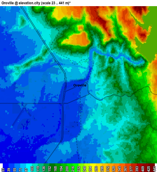
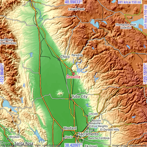
These maps also provides idea of topography and contour of this city, they are displayed at different zoom levels. More info about maps, scale and edge coordinates you can find below images.
| \ | Map #1 | Map #2 | Topo.Map |
| Scale [m] | 34..254 m | 23..441 m | × |
| Scale [ft] | 112..833 ft | 75..1447 ft | × |
| Average | 85.5 m = 281 ft | 124.5 m = 408 ft | × |
| Width | 7.54 km = 4.7 mi | 15.08 km = 9.4 mi | 241.3 km = 149.9 mi |
| Height | 7.54 km = 4.7 mi | 15.08 km = 9.4 mi | 241.2 km = 149.9 mi |
| ↑Max Latitude | 39.547834° | 39.581712° | 40.59033° |
| Latitude at center | 39.51394° | 39.51394° | 39.51394° |
| ↓Min Latitude | 39.480029° | 39.446102° | 38.42061° |
| ← Min Longitude | -121.601705° | -121.645651° | -122.96401° |
| Longitude center | -121.55776° | -121.55776° | -121.55776° |
| →Max Longitude | -121.513815° | -121.469869° | -120.15151° |
Nearby cities:
Cities around Oroville sort by population:
• Paradise elevation 543 m
27.9 km,  348°
348°
• Live Oak 23 m
27.9 km,  198°
198°
• Oroville East 296 m
7.1 km,  92°
92°
• Thermalito 67 m
2.5 km,  263°
263°
• Gridley 28 m
20.4 km,  214°
214°
• South Oroville 58 m
2 km,  166°
166°
• Durham 47 m
25.4 km,  305°
305°
• Palermo 59 m
8.9 km, 169°
• Loma Rica 123 m
25.5 km,  151°
151°
• Biggs 28 m
17.5 km,  229°
229°
• Berry Creek 641 m
19.7 km,  42°
42°
• Challenge-Brownsville 795 m
25.9 km,  102°
102°
Multilingual:
 En español:
Oroville elevación 49 m.
 En France:
Oroville élévation 49 m.


Sources and notes:
- [note 1] Map square and city borders are not equal. Map elevation data is calculated only from area inside that square.
- [src 1] Elevation data from geonames database provided with same terms of usage.
- [src 2] The elevation map of Oroville is generated using elevation data from NASA's 3 arcsec (90m) resolution SRTM data.
- [src 3] Base (background) map © OpenStreetMap contributors tiles are generated by Geofabrik and OpenTopoMap.
Copyright & License:
This Oroville Elevation Map is licensed under CC BY-SA. You may reuse any part from this page, if you give a proper credit by linking to this URL:
 More info on terms of use page.