Los Molinos elevation
Los Molinos (California, Tehama County), United States elevation is 70 meters and Los Molinos elevation in feet is 230 ft above sea level [src 1]. Los Molinos is a populated place (feature code) with elevation that is 209 meters (686 ft) smaller than average city elevation in United States.
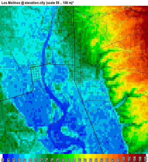
Below is the Elevation map of Los Molinos, which displays elevation range with different colors. Scale of the first map is from 59 to 108 m (194 to 354 ft) with average elevation of 74 meters (=243 ft) [note 1]
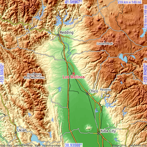
These maps also provides idea of topography and contour of this city, they are displayed at different zoom levels. More info about maps, scale and edge coordinates you can find below images.
| \ | Map #1 | Topo.Map |
| Scale [m] | 59..108 m | × |
| Scale [ft] | 194..354 ft | × |
| Average | 74 m = 243 ft | × |
| Width | 7.48 km = 4.6 mi | 239.5 km = 148.8 mi |
| Height | 7.48 km = 4.6 mi | 239.5 km = 148.8 mi |
| ↑Max Latitude | 40.054915° | 41.08967° |
| Latitude at center | 40.02127° | 40.02127° |
| ↓Min Latitude | 39.987608° | 38.93588° |
| ← Min Longitude | -122.144215° | -123.50652° |
| Longitude center | -122.10027° | -122.10027° |
| →Max Longitude | -122.056325° | -120.69402° |
Nearby cities:
Cities around Los Molinos sort by population:
• Chico elevation 64 m
39.5 km,  145°
145°
• Paradise 543 m
50.1 km,  125°
125°
• Red Bluff 94 m
20.9 km,  326°
326°
• Magalia 707 m
50.2 km,  117°
117°
• Orland 80 m
31.5 km,  195°
195°
• Corning 85 m
12.4 km,  212°
212°
• Durham 47 m
48.9 km, 148°
• Cottonwood 132 m
43.3 km,  339°
339°
• Hamilton City 48 m
31.8 km,  166°
166°
• Rancho Tehama Reserve 168 m
25.6 km,  268°
268°
• Forest Ranch 741 m
39.6 km,  113°
113°
• Gerber 71 m
5.8 km,  312°
312°
Multilingual:
 En español:
Los Molinos elevación 70 m.
 En France:
Los Molinos élévation 70 m.
 Auf Deutsch:
Los Molinos höhe über dem Meeresspiegel ist 70 m.

Sources and notes:
- [note 1] Map square and city borders are not equal. Map elevation data is calculated only from area inside that square.
- [src 1] Elevation data from geonames database provided with same terms of usage.
- [src 2] The elevation map of Los Molinos is generated using elevation data from NASA's 3 arcsec (90m) resolution SRTM data.
- [src 3] Base (background) map © OpenStreetMap contributors tiles are generated by Geofabrik and OpenTopoMap.
Copyright & License:
This Los Molinos Elevation Map is licensed under CC BY-SA. You may reuse any part from this page, if you give a proper credit by linking to this URL:
 More info on terms of use page.